Domain names are the alternate address names for IP address, Domain names(eg. example.com) are the easiest way to remember the web address instead on remember IP address(eg. 255.168.48.9). And these domain names are pointing to IP address. Domain Name System(DNS) matches the domain name to IP address.
Every device in the public internet have IP address which is in numeric format(eg. 255.168.48.9), and this string of numeric numbers are difficult to remember, so we assign Domain names for this IP address.
A Domain name(DN) can be used as a website, email accounts
A domain consist of a minimum a Top Level Domain(TLD) and a Second-Level Domain(SLD)
http://example.com/
“.com” is the Top Level Domain
“example” is the Second level domain(SLD) of .com
Structure of Domain Name
Domain name structure can be separated by periods
the right side of the domain is called extensions which are called as TLDs
and left to that called as Second Level Domain(SLD).
SLD.TLD
SubDoamin.SLD.TLD
Sub Domain
A Sub Domain is the subdivision of domain name and you can place unique content for each sub domain or use for unique purpose for each sub domain
en.example.com for English version
ch.example.com for Chinese version
http://www.example.com/
“www” is the sub domain of example.com
another example is
http://blog.example.com/
“blog” is the sub domain of example.com
A domain can have multiple subdomains, it all depends on your hosting providers, some allow to create unlimited number of subdomains for free and some limit the number.
Top Level Domain (TLD)
Top Level Domains are also called as extensions which are the last part of the domain name (suffix of a domain) or the right side of the domain name eg.: .com, .net, .info
There are different types of TLDs
gTLD, ccTLD, geoTLD
Generic Top Level Domain(gTLD)
gTLDs are one of the category in TLDs
some gTLDs are available to register for any one and someor sponsored TLDs which can be registered by only who engaged with that industry
.com, .net, .org .info – anyone can register these domains
.biz, .name, .pro anyone can register these domains but use for their specified purpose
Vijayawada is located in the north side of the Krishna River bank in Krishna District, Andhra Pradesh, India(Bharat). Vijayawada is part of crda(Capital Region Development Authority). Vijayawada is the second most populists city in Andhra Pradesh, and which is called as Business City of Andhra Pradesh
CRDA – Capital Region Development Authority is a government Department run by Andhra Pradesh state. The major purpose of cdra is to authorize the capital plan, Co-ordination, Execution, Supervision, Financing, Funding and for Promoting and Securing the Planned Development of the Capital Region.
After bifurcation of Andhra Pradesh(AP) in to two states Telangana, Andhra Pradesh. The Andhra Pradesh Government make a bill “Andhra Pradesh Capital Region Development Authority” Act 2014 for the declaration of new capital area for Andhra Pradesh
Guntur is one of the city in Guntur Mandal, located in Guntur district of Andhra Pradesh, India. It is the only municipal corporation in Guntur district. The total geographical area of the Guntur is 45.71 Sq.Km. Guntur is the part of capital region development authority(CRDA).Guntur is established in the year 1866.The distance from Vijayawada to Guntur is 37.5 km.The city is well known for Chilies and tobacco.
City
Guntur
Mandal
Guntur
District
Guntur
Alternate Name
Garthapuri(Alternate Name for Guntur)
state
Andhra Pradesh
Country
India(bharat)
Population
44,713
Density Of Population
429
Language
Telugu
TimeZone
UTC/GMT +5:30, IST
Nick Name
City of Spices
Telephone Code
0863
Pincode
522XXX
Agriculture
Guntur City and its region is a major commercial center in India. The major crops grown here are Cotton, Paddy and Tobacco.
Total irrigated area 248.00 hectares
Unirrigated area 477.20 hectares
Area not available for cultivation 2754.80 hectares
Livestock
Total milk production 48,33,993 liters/Year
Total egg production in a year 4.29 Crores
Demographics
As per the census of 2011, there were 169007 households residing in the Guntur Municipal Corporation. The total population of the GMC is 670073. The GMC have 483261 literates.There were XXXX voters in GMC.
Total Population
Male Population
Female Population
Population
670073
331435
338638
0-6 Years Population
66124
33923
32201
Literates
483261
254018
229243
Illiterates
186812
77417
109395
Voters
How To Reach
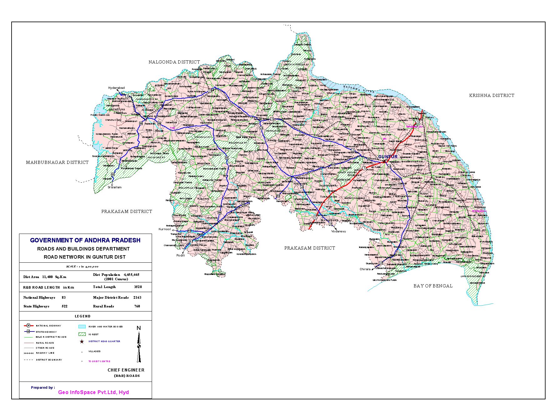
Road
The city is the territorial headquarters of State Transport System. It is joined with all the real urban areas the nation over through different major and neighborhood roadways.
There are a couple of major expressways, Madras-Guntur-Kolkata Expressway, Guntur-Hyderabad-Mumbai Highway. Inside of the city, the movement basically streams utilizing the purported ring-streets, internal and external ring-streets. Normal methods of street transport inside of the city will be city transports and auto-rickshaws, manual rickshaws can in any case be seen.
The city is additionally some piece of the Golden Quadrilateral framework, a noteworthy transportation venture under advancement.
The distance from Vijayawada to Guntur is 37.5 km.
Railways
Guntur City is the host of one of the Divisional base camp and a notable travel point in the Indian Railroads System.
All the 4 metro urban areas and state capitals can be gotten to through this travel point. It made out of few Stations: the Central/Main Station (close Arundel Pet and Railpet) and the others at Nallapadu, University-Center(Namburu), New Guntur(Reddipalem).
Two other significant travel directs closer toward Guntur are: Tenali and Vijayawada with a future arrangement of running rural trains in the rural locale.
The Indian Railways is one of the most helpful and effective arrangement of the drive for the general population all through India.
Air
The nearest domestic airport is Vijayawada airport.
And international Airport is Hyd and Chennai.
Geography
latitude: 16.4158347
longitude:80.6507268
Rainfall: 26 C/F
Wind: 26 Km/h
Education
There are 120 schools in the GMC.
Elementary schools – 85
High Schools – 10
Upper Primary Schools – 25
around 90 colleges
universities 10
some of the colleges in Guntur are
Temples
ISKCON – Malla Reddy Nagar, Near Mahatma Gandhi College, Reddy College Road, AT Agrahar, 3rd Line, Guntur
Anjaneya Swamy Temple – Old Guntur, Guntur
Sivalayam – Old Guntur, Guntur
Sai Baba Temple – Gorantla, Guntur
Sri Subramanya Swamy Temple – Velangini Nagar, Guntur
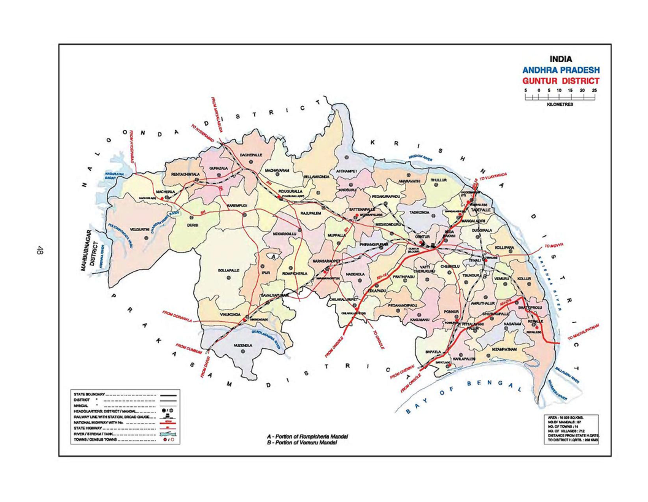
Guntur District is situated in Andhra Pradesh along the east bank of Bay of Bengal. It has a coastline of around 100 kilometers. Guntur city is the biggest and legislative center for the Guntur District. The Guntur District is the notable place for learning. The primary language in this area is Telugu.
Guntur region covers a range of 11,391 Sq.km and has a populace of 4,465,144. The Krishna River frames the northeastern and eastern limit of the region, isolating Guntur District from Krishna District. The area is limited on the southeast by the Bay of Bengal, on the edge of the south by Prakasam District, on the frontier of the west by Mahbubnagar District, and on the northwest by Nalgonda District.
Guntur District is the home of ancient significance like Amaravati, Bhattiprolu and Sitanagaram landmarks. Agriculture, Industry, and business are adding additional importance to the Guntur District. The place is known for the large scale of transportation. The focal point of the Guntur District is the leading Textile Industries. Also, the Guntur territory economy is based on the agriculture segment that is universally exports of its rich cash crops like chilies, cotton, and tobacco.Paddy, tobacco, Cotton, and Chilies are the primary horticultural items developed in the region.
Guntur District is partitioned into 57 mandals.Guntur District plays the key role in the development of the Capital city for the Andhra Pradesh. It is the part of the capital region development authority(CRDA). Spots of verifiable importance in the District are Amaravathi, Ponnur, Bhattiprolu, Vinukonda, Kotappakonda, Undavalli caverns, Gurazala, Macherla, Kondavid fortress, Mangalagiri and the archeological exhibition in Guntur.
District
Guntur
Alternate Name
Garthapuri(Alternate Name for Guntur)
state
Andhra Pradesh
Country
India(bharat)
Population
44,713
Density Of Population
429
Number of Villages
729
Number of Towns
11
Number of Mandals
57
Number of Municipalities
9
Number of Municipal Corporations
1
Number of Revenue Divisions
4
Inhabitted villages
1755
Number of Grama Panchyaths
120
Language
Telugu
TimeZone
UTC/GMT +5:30, IST
Guntur District Map
History
The first Sanskrit name (old Vedic society/custom) for Guntur was Garthapuri. The “Agasthyeswara Sivalayam” in the old city of Guntur is an antiquated sanctuary for Siva. It is said that Agastya constructed the sanctuary in the last Treta-Yuga around the Swayambhu Linga and subsequently the name. The “Nagas” were said to have governed the district. The spot of Sitanagaram and the Guthikonda Caves can be followed (through Vedic Puranas) back to the last Treta-Yuga and Dwapara-Yuga (Traditional Timescale: 1.7 to 0.5 million years prior, Ref). However, these are not experimentally evident truths like the vast majority of the Vedic old stories.
Guntur District is home to the second most seasoned confirmation of people in India, as Paleolithic (old stone age) executes. Antiquated history can be followed from the season of Sala rulers who ruled amid the fifth century BCE. The most punctual reference to Guntur, a variation of Guntur, originates from the king Ammaraja I (922-929 CE), the Vengi Chalukyan King. Guntur additionally shows up in another two engravings dated 1147 and 1158.
Since the start of Buddhist age, Guntur stood first in matters of society, training and human advancement. Gautama Buddha lectured at Dharanikota/Dhanyakatakam close Guntur and led Kalachakra service, which takes its relic to 500 BCE. Taranatha, a Buddhist minister composes: “On the full moon of the month Caitra in the year taking after his edification, at the considerable stupa of Dhanyakataka, the Buddha radiated the mandala of “The Glorious Lunar Mansions” (Kalachakra).
Guntur was progressively governed by celebrated traditions, for example, the Satavahanas, Andhra Ikshvakus, Pallavas, Ananda Gotrikas, Vishnukundina, Kota Vamsa, Chalukyas, Cholas, Kakatiyas, Vijayanagara and Qutb Shahis amid old and medieval times. The popular skirmish of Palnadu which is cherished in legend and writing as Palnati Yuddham was battled in Guntur locale in 1180.
Guntur turned out to be a piece of the Mughal domain in 1687 when the sovereign Aurangzeb vanquished the Qutb Shahi sultanate of Golconda, of which Guntur was then a section. In 1724, Asaf Jah, an emissary of the domain’s southern territories, proclaimed his freedom as the Nizam of Hyderabad. The waterfront regions of Hyderabad, known as the Northern Circars were possessed by the French in 1750. Raja Vasireddy Venkatadri Nayudu (1783-1816) moved his capital from Chintapalli in Krishna area to Amaravati over the waterway Krishna. He governed with kindheartedness and fabricated numerous sanctuaries in Guntur locale. Guntur was brought under the control of the British East India Company by 1788 and turned into an area of Madras Presidency.
The Guntur locale assumed a huge part in the battle for autonomy and the arrangement of Andhra Pradesh. The northern, Telugu-talking areas of Madras state, including Guntur, supported for a different state after autonomy and the new condition of Andhra Pradesh was made in 1953 from the eleven northern regions of Madras.
Formation of Guntur District
The formation of Guntur area was 1st October 1904 with Head Quarters at Guntur later the bifurcating Krishna and Nellore Districts. Before 1859, there was ‘Guntur District’ with Head Quarters at Guntur but with a different legislation. In 1859, the area was abrogated and was partitioned up in the middle of Masulipatnam and Rajahmundry areas which were renamed as Krishna and Godavari. In 1904,
Guntur area was constituted into a different free region with the
territories of the Taluka of Tenali, Bapatla, Guntur, Sattenapalli, Narasaraopet, Vinukonda and Palnadu of old Krishna area and Ongole taluk from Nellore area.
Tenali taluk was part on 1-7-1909 into two taluks to be specific Tenali and Repalle. This area subsequently framed in 1904 was held in place till February 1970. In February 1970, while framing another region with Ongole as its base camp parts of Bapatla and Narasaraopet taluks and the entire of Ongole taluk were taken to Prakasam District leaving Guntur region with just eight taluks in particular Guntur, Sattenapalli, Tenali, Repalle, Bapatla, Narasaraopet, Vinukonda and Palnadu.
With impact from first November 1977 once more, these eight taluks were revamped into eleven taluks by redesigning the sub-taluks of Mangalagiri, Ponnuru and Macherla as taluks splitting the old taluks of Guntur, Bapatla, and Palnadu individually.
Later, 1980, Chilakaluripet taluk was framed as 12th taluk taking parts from Narasaraopet and Guntur taluks.Amid 1981-82, Repalle taluk was separated into two taluks Pallapatla and Repalle, Tenali turned into two taluks Tenali and Emani, Guntur taluk into Guntur and Prathipadu, Sattenapalli taluk into three taluks Sattenapalli, Tyalluru, and Rajupalem. Vinukonda Taluk into Vinukonda, Ipuru, and Gurazala into Gurazala and Piduguralla subsequently bringing 19 taluks into presence before the end of 1981-82. Despite the fact that it was pulled over in 1981-82 to constitute Amrathaluru and Tadikonda additionally as taluks
to match with the 21 Panchayat Samithis yet they didn’t appear.
57 Mandals have appeared with impact from 25-5-1985 in the spot of recent taluks and Firkhas. The principle goal of the Government in keeping Mandals is to take organization closer to the individuals and to make the most sensible unit of organization.
Demographics
In 2011, Guntur had a populace of 4,887,813 of which males were 2,440,521 and females were 2,447,292. In 2001, statistics, Guntur District had a populace of 4,465,144 of which males were 2,250,279 and 2,214,865 were females. Comparing to total Maharashtra population Guntur District constituted 5.78 percent population. In 2001, enumeration, the Guntur District was at 5.86 percent of Maharashtra population.There were 12,878,000 households residing in the Guntur District.
There was the change of 9.47 percent in the population contrasted with the population according to 2001. In the past enumeration of India 2001, Guntur District recorded increment of 8.72 percent to its population contrasted with 1991.
Density of Population
The Density of Population of Guntur District for 2011 is 429. The Density of Population of Guntur District for 2001 is 392. The total area of Guntur District is 11,391 square kilometers.
Child Population
In 2011, the total child population of Guntur District has 2,960,441 of which males were 1,634,726 and females were 1,325,715. In 2001, statistics, the total child population of Guntur District has 2,455,965. In 2011, Children under 0-6 framed 10.14 percent of Guntur District contrasted with 12.06 percent of 2001. There was the net change of – 1.92 percent in this contrasted with the past registration of India.
Literacy Rate
In 2011, the total literates of Guntur District have 2,960,441 of which males were 1,634,726 and females were 1,325,715. In 2001, statistics, the total literates of Guntur District have 2,455,965. In 2011, the literacy rate of Guntur District is 67.40 percent compared to 62.54 percent of 2001.
Total
Male
Female
Rural
Rural Male
Rural Female
Urban
Urban Male
Urban Female
Population
4,889,230
2,441,128
2,448,102
3,232,485
1,620,120
1,612,365
1,656,745
821,008
835,737
0-6 Years Population
466,285
239,408
226,877
314,670
161,846
152,824
151,615
77,562
74,053
Literates
3,006,999
1,660,019
804,246
1,824,611
1,032,513
792,098
1,182,388
627,506
554,882
Illiterates
1,415,946
541,701
874,245
1,093,204
425,761
667,443
322,742
115,940
206,802
Education
As per 2011 Census
Tenali, Guntur, and Tadepalli recorded as the highest literacy rate Mandals in Guntur District.
Bollapalle, Nuzendla, and Veldurthi recorded as the lowest literacy rate Mandals in Guntur District
School\Institution
Number
Primary school
3062
Upper Primary
489
High schools
652
Higher Secondary Schools
7
Junior colleges
273
Polytechnic colleges
21
Pharmacy colleges
25
Engineering colleges
49
MBA colleges
49
MCA colleges
45
Administration
The Guntur District is isolated into four Revenue divisions, in particular, Guntur division, Tenali division, Narasaraopet division and Gurazala division.Gurazala division was framed in the year 2013. These are sub-partitioned into 57 Mandals.These 57 Mandals partitioned into 729 Villages, 11 towns, 9 Municipalities and 1 Municipal corporation.Guntur city is the main metropolitan city.
Parliament Constituency
Member of Parliament(MP)
Month Year
Guntur
Shri. Galla Jaydev
May 2014
Bapatla
Shri. Malyadri Sriram
May 2014
Narasaraopeta
Shri. Rayapati Sambasiva Rao
May 2014
Assembly Constituency
Member of Legislative Assembly(MLA)
Month Year
Pedakurapadu
Kommalapati Sridhar
May 2014
Tadikonda
Tenali Sravana Kumar
May 2014
Mangalagiri
Alla Ramakrishna Reddy
May 2014
Ponnur
Dhulipalla Narendra Kumar
May 2014
Vemuru
Nakka Ananda Babu
May 2014
Repalle
Anagani Satya Prasad
May 2014
Tenali
Alapati Rajendra Prasad
May 2014
Bapatla
Kona Raghupathi
May 2014
Prathipadu
Ravela Kishore Babu
May 2014
Guntur West
Modugula Venugopala Reddy
May 2014
Guntur East
Mohammad Musthafa Shaik
May 2014
Chilakaluripet
Prathipatti Pulla Rao
May 2014
Narasaraopet
DR. Gopireddy Srinivasa Reddy
May 2014
Sattenapalle
Kodela SivaPrasada Rao
May 2014
Vinukonda
G.V. AAnzaneyulu
May 2014
Gurajala
Yarapathineni Srinivasa Rao
May 2014
Macherla
Pinnelli Rama Krishna Reddy
May 2014
Agriculture
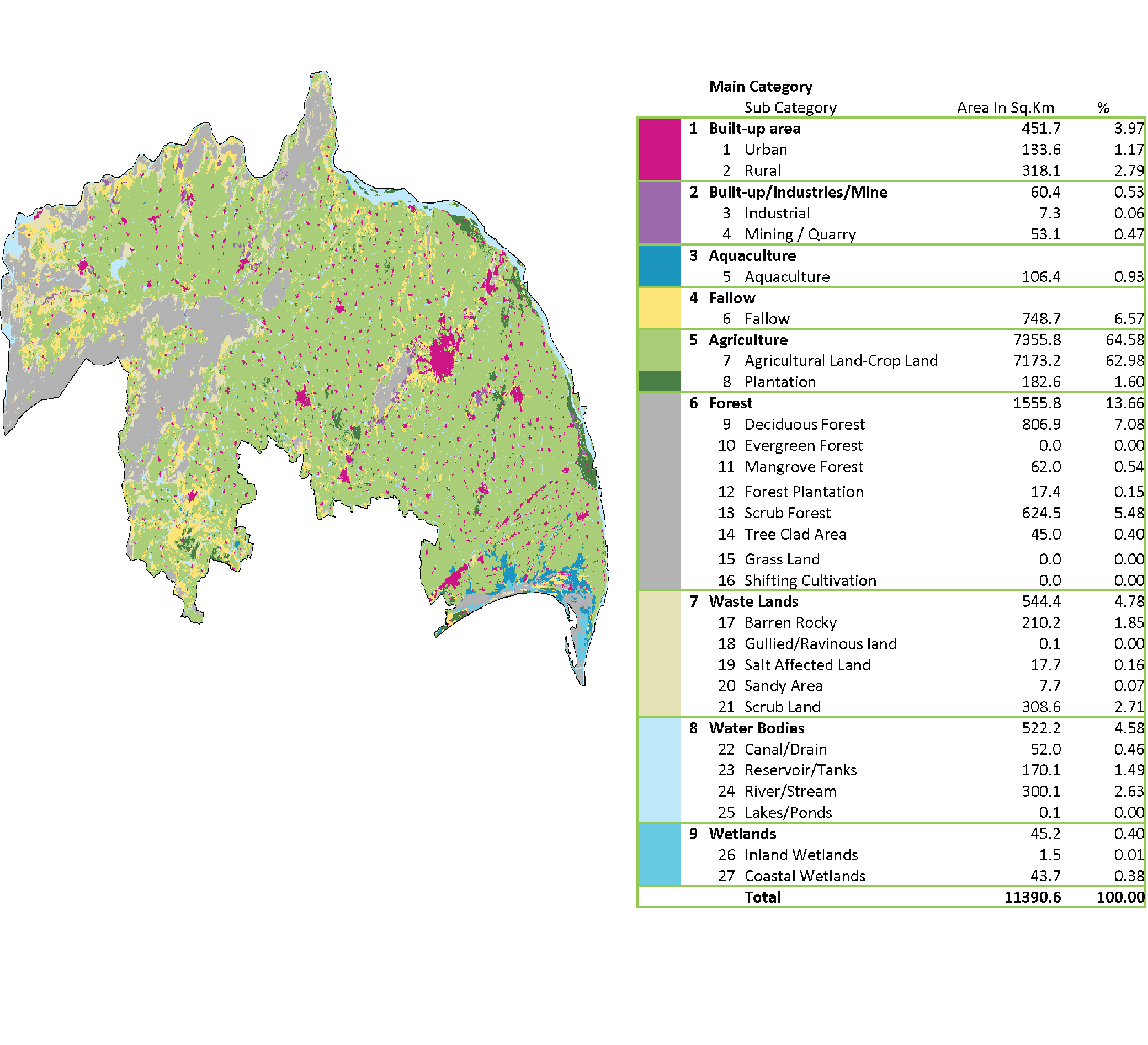
The total agriculture land is 7355.5 Sq Km which forms 64.58% to the geographical area.The cropland is 7173.2Sq Km which forms 62.98% to the total agriculture land.The Plantation land is 182.6Sq Km which forms 1.60% to the total agriculture land.The total fallow land is 748.7 Sq Km which forms 6.57% to the geographical area.
Land
Area in Sq. Km
Forest Area
1555.8
Total Agriculture Land
7355.8
Non Agriculture Land
1573.03
Crop Land
7173.2
Planitation
182.6
Irrigation
The two Major watering system ventures in the region are
Old Krishna Ayacut, now renamed as Prakasam Barrage with an ayacut of 202032 hectares and the another is Nagarjuna Sagar Project with an ayacut of 254583 hectares.
Both the activities are built on the waterway Krishna. A medium Irrigation channel by name Guntur Branch Canal (GBC) having an ayacut of the 10823 hectares and the Minor Irrigation resources like tanks, channel focuses, tube wells and so on., are giving watering system.
Soils
The dirt, as a rule, is exceptionally ripe and they are comprehensively named Black cotton, Red loamy and sandy loamy. The black cotton zone is in 70%, Red loamy in 24% and sandy loamy in around 6% of the range in the locale.
Crops
The prevalent yields developed in the locale are paddy, jowar and bajra among oats, black gram, green gram and red gram among heartbeats, cotton, chilies, turmeric and tobacco among non-nourishment and business crops.
Forest
The total forest area is 1555.8 Sq Km which forms 13.66% to the total geographical area.
The deciduous forest is 806.9 Sq Km which forms 7.08% to the total forest area.
The mangrove forest is 62.0 Sq Km which forms 0.54% to the total forest area.
The forest Plantation is 17.4 Sq Km which forms 0.15% to the total forest area.
The scrub forest is 624.5 Sq Km which forms 5.48% to the total forest area.
The tree-clad area is 45.0 Sq Km which forms 0.40% to the total forest area.
The major forest produce in the district is timber while minor forest produce are bamboo and beedi leaves.
Geography
latitude: 16.779027
longitude: 80.124906
Temperature: 36 C/F
Wind: 21 Km/h
Altitude: 33 m
Guntur Road Map
Land Utilisation
The total geographical area of the Guntur district is 1132823 Hectares.
Built Up Area (3.97%)
The total built up area 451.7 Sq Km which forms 3.97% to the total geographical area.The urban area is 133.6Sq Km which forms 1.17% to the built up area.The rural area is 318.1Sq Km which forms 2.79% to the built up area.
Industrial Area(0.53%)
The total industrial area 60.4 Sq Km which forms 0.53% to the total geographical area.The Industrial area is 7.3Sq Km which forms 0.06% to the industrial area.The mining area is 53.1Sq Km which forms 0.47% to the industrial area.
Aquaculture(0.93% )
The total area for the aquaculture is 106.4 Sq Km which forms 0.93% to the total geographical area.
Agriculture Land(64.58%)
The total agriculture land is 7355.5 Sq Km which forms 64.58% to the geographical area.The cropland is 7173.2Sq Km which forms 62.98% to the total agriculture land.The Plantation land is 182.6Sq Km which forms 1.60% to the total agriculture land.The total fallow land is 748.7 Sq Km which forms 6.57% to the geographical area.
Forest(13.66%)
The total forest area is 1555.8 Sq Km which forms 13.66% to the total geographical area.
Waste Lands(4.78%)
The total wasteland is 544.4 Sq Km which forms 4.78% to the total geographical area.The barren rocky land is 210.2 Sq Km which forms 1.85% to the total wasteland.The gullied land is 0.1 Sq Km which forms 0.00% to the total wasteland.The salt-affected land is 17.7 Sq Km which forms 0.16% to the total wasteland.The sandy area is 7.7 Sq Km which forms 0.07% to the total wasteland.The scrub land is 308.6 Sq Km which forms 2.71% to the total wasteland.
Water Bodies(4.58%)
The total water bodies are 522.2 Sq Km which forms 4.58% to the total geographical area.The canals/drains are 52.0 Sq Km which forms 0.46% to the total water bodies.The Reservoir/tanks are 170.1 Sq Km which forms 1.49% to the total water bodies.The rivers/streams are 300.1 Sq Km which forms 2.63% to the total water bodies.The lakes/ponds are 0.1 Sq Km which forms 0.00% to the total water bodies.
Wetlands(0.40%)
The total wetlands are 45.2.2 Sq Km which forms 0.40% to the total geographical area.The inland wetlands are 1.5 Sq Km which forms 0.01% to the total wetlands.The coastal wetlands are 43.7 Sq Km which forms 0.38% to the total wetlands.
Rivers and Drainages
The Important waterways that cross the area are the Krishna, the Chandravanka, and the Naguleru. The rivers Chandravanka and the Naguleru are the tributaries of river Krishna.
Aside from the aforementioned waterways and streams, the Romperu drainage basin, the Tungabhadra channel, the Bhattiprolu channel, and the Repalle channel are the facilities accessible in the region.
Hills and Elevations
The Principal slope scopes of the area are Nallamalais, the Venkatayapalem range, and the Kondavedu slopes.
The Nallamalai off-shoots
The grandiose Nallamalais of the Kurnool region with their “U” formed terminal off-shoots skirt the Palnadu range. The slopes in this part are generally made out of slates and quartzites. A vital waterfall in this nation is “Ethipothala” arranged on a scope of slopes.
The Venkatayapalem Range
The following essential slope extent is Venkatayapalem named after a town in Sattenapalli territory and is made out of slates and quartzites. . It has long been known for the old working of precious stones. Its most astounding point is “Maidarsal” (447 m).
Kondavedu Range
The Kondavedu extent close Narasaraopet is made out of stone shake and expands about 19 Km, enlisting a most extreme tallness of 523 m. A couple of kilometers to its west is the secluded slope of Yellamanda (489 m), also called as “Kotappakonda”. The hill slope traces are expanding towards Addanki in the direction of South.
Tourism
There are really numerous traveler spots in the Guntur District. Important among them are Nagarjuna Sagar, Nagarjuna Konda, Mangalagiri, Amaravathi, Ponnur, Pedakakani, Govada, Kotappakonda and Satrasala, Undavalli caves, Kondaveedu fort, the waterfalls at Ethipotala and Guttikondabilam have the ancient historical eminence.
Nagarjuna Sagar Dam
The Nagarjuna Sagar Dam is the World`s most highest Masonry gravity dam. The State Government is making changes to create Nagarjuna Sagar as a spot of vacation destination on the lines of Brindavan and Botanical greenery enclosures.
Amaravathi
Amaravathi is arranged at 35 K.Ms. the North-west of Guntur on the banks of waterway Krishna. It has the stream of pilgrims throughout the year.There are a world popular Buddhist stupas and Buddhistic tales images and so on.,
Kotappa Konda
Kotappa Konda village of Kondakavuru. The Presiding Diety of this spot is Trikoteswara Swamy arranged on the hillock and is one of the prominent pilgrims.
Mangalagiri
Mangalagiri is a slope of happiness by ethicalness of the area of the well-known Ruler called Lakshmi Narasimha Swamy. The Lord is generally known as Panakala Narasimha Swamy or Panakala Swamy.
Ponnur
Ponnur is well known for the Lord Bhavanarayana Swamy, drawing in an expansive number of Pilgrims. Among alternate sanctum, Sri Anjaneya Swamy sanctum and that of Garutmanta is noted in the region.
Ethipothala waterfalls
Ethipothala waterfalls is a mountain stream falling down the slopes from a stature of 22 meters the Ethipothala waterfalls are a brilliant sight of the force and excellence of nature. This Waterfall is among the rising vacation spots in Andhra Pradesh.
Suryalanka Beach
Suryalanka Beach is found 9 km from the Bapatla in Guntur District of Andhra Pradesh. It is found 50 km south of Guntur City. Otherwise called the Bapatla Beach, it draws countless on weekends and occasions.
Guthikonda Caves
The appeal of these old caverns lies in the way that maharishis and holy people pondered in the holes. The Guthikonda Caves is famously known as the Dakshina Kasi. A fascinating piece of the Guthikonda Caves is the understood Guthikonda Bilam.
Kondaveedu Fort
Kondaveedu Fort is to be found at a separation of 25 km from Guntur. Kondaveedu stronghold was assembled by Anaphora Reddy in the 1250 A.D and later created by Ana Venkata Reddy. Them two were great leaders of the Reddy tradition known as the kind supporters of the workmanship and society.
Undavalli Caves
These holes have been cut out of strong sandstone on a slope in the 500 A.D. There are a few holes. It is the principle hole has a place with the most punctual illustrations of Gupta structural engineering, fundamentally primitive rock-cut religious community cells cut into the sandstone slopes.
Uppalapadu Bird Sanctuary
Uppalapadu is a position of flying birds relocation and a town close Guntur City. It is likewise a presumed winged animal asylum. Home to around 40 types of birds from Siberia including pelicans and white ibis, this asylum is comparable to Pulicat Sanctuary in Nellore District.
Major Exportable Item
Mango and other fruit products, chilies, burnt lime, tobacco leaf, and products.
Availability of Minerals
The region contains tremendous stores of concrete evaluation limestone, iron metals, copper and lead minerals. The stores of monetary mineral are as per the following
Limestones
Narjee limestone is widely present in the Palnadu district which is utilized for the production of concrete.
Jewels
Broad mining was done in the past in the region of Kollur town in Sattenapalli territory on the banks of Krishna stream. It is trusted that the celebrated stone “Kohinoor” a precious stone was discovered at Kollur. The precious stone mines in the region are arranged near to Madugula, Mallavaram and Sarangapalli hills.
Diatomaceous Earth
It happened at Thimmayapalem and Innavolu near to the region Vinukonda.
Copper and Lead Ores
The copper and lead exist in the region of Agnigundala and Karempudi. The Ores of copper and lead are broadly found in these zones and extraction is being completed.
Iron-Ore
Poor quality of iron-mineral magnetite quartzites is occurring near the Thumurukota near to the Macherla.
Gypsum
Gypsum takes place at sparsely dispersed plates at an extent of one to three meters in the marine residues near to the Santaravuru.
Quartz
These are a few reefs of quartz at Palnadu, Sattenapalli, Narasaraopet and Vinukonda which may discover for the utilization in glass make.
Kankar
Kankar or calcareous knobs, utilized for production of lime, occurred in the region near to the Chebrolu, Mangalagiri, Pedakakani, Venkatayapalem, and the Nadendla regions.
White Clays
White Clays are occurring near to the region Macherla.
Granite
Gondwana rock stones are helpful in building development. Palnadu limestone was used for the development of stupas amid the Buddhist period.
The total industrial area 60.4 Sq Km which forms 0.53% to the total geographical area.The Industrial area is 7.3Sq Km which forms 0.06% to the industrial area.The mining area is 53.1Sq Km which forms 0.47% to the industrial area.
Amruthalur mandal is located in Guntur district of Andhra Pradesh, India(Bharat). Amruthalur mandal is the part of capital region development authority(CRDA).It is 39 km far from the Guntur city and 53 Km far from Vijayawada. The Mandal boundaries are Tsundur Mandal, Tenali Mandal, Vemur Mandal, Cherukupalli Mandal, Ponnur Mandal and Pittalavanipalem Mandal
Mandal(SubDistrict)
Amruthalur
District
Guntur
state
Andhra Pradesh
Country
India(bharat)
Number of Villages
13
Population
44,713
Language
Telugu
TimeZone
UTC/GMT +5:30, IST
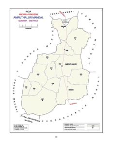
Amruthalur Mandal Map
Villages in Amruthalur Mandal
Name of the Village
Area
HouseHolds
Population
Pincode
Amruthalur
1,499
1833
6,524
522325
Bodapadu
350
475
1,423
522341
Govada
1,650
398
2055
522341
Intur
2,184
1676
5715
522341
Koru
514
215
757
522312
Kuchipudi
1075
1903
6788
522313
Moparru
877
972
3324
522312
Mulpur
1,292
1558
5,387
522261
Panchalavaram
914
529
1,848
522325
Peddapudi
580
935
3,395
522325
Pyaparru
433
817
2,465
522341
Thurumella
485
398
1,422
522312
Yelavarru
580
625
2,055
522341
Demographics
As per the census of 2011, there were 15068 households residing in the Amruthalur mandal. The total population of the Amruthalur mandal is 58,447. The Amruthalur mandal has 27,585 literates.There were 37871 voters in Amruthalur mandal.
Name of the Village
Total Population
Male Population
Female Population
0-6 Yr Total Population
0-6 Yr Male Population
0-6 Yr Female Population
Total Voters
Male Voters
Female Voters
Amruthalur
6,524
3,297
3,227
477
237
240
5440
2670
2769
Bodapadu
1,423
726
697
117
67
50
1256
613
643
Govada
3,610
1,757
1,853
245
122
123
3051
1478
1573
Intur
5,715
2,919
2,796
482
251
231
4694
2250
2444
Koru
757
373
384
55
28
27
650
327
323
Kuchipudi
6788
3299
3489
619
290
329
3844
1867
1977
Moparru
3324
1666
1658
263
145
118
2728
1349
1379
Mulpur
5,387
2,679
2,679
490
255
235
1590
776
814
Panchalavaram
1,848
924
924
166
84
82
1002
341
661
Peddapudi
3,395
1,710
1,685
333
185
148
2739
1338
1401
Pyaparru
2,465
1,216
1,249
94
75
169
1906
760
1146
Thurumella
1,422
646
776
99
52
47
1303
618
685
Yelavarru
2,055
1,021
1,034
180
102
78
1573
769
804
Education
Name of the Village
Number of Schools
Number of Colleges
6-14 Yr Children
Total Literates
Male Literates
Female Literates
Total Illiterates
Male Illiterates
Female Illiterates
Literacy Rate
Illiteracy Rate
Amruthalur
8
NA
547
4,483
2,447
2,036
2,041
850
1,191
68.71
31.28
Bodapadu
3
NA
143
978
549
429
445
177
268
68.72
31.27
Govada
3
NA
339
2,352
1,205
1,147
1,258
706
552
65.15
34.84
Intur
7
NA
564
3,993
1,929
2,064
1,72 2
990
732
69.86
30.13
Koru
1
NA
63
536
281
255
221
92
129
70.80
29.19
Kuchipudi
6
NA
601
4310
2277
2033
2478
1022
1456
63.49
36.50
Moparru
5
NA
405
2304
1219
1085
1020
447
573
69.31
30.68
Mulpur
6
NA
657
3,553
1,845
1,708
1,834
834
1,000
65.95
34.04
Panchalavaram
2
NA
202
1,191
641
550
657
283
374
64.44
35.55
Peddapudi
4
NA
423
2,209
1,192
1,017
1,186
518
668
65.06
34.93
Pyaparru
4
NA
252
852
741
1,593
364
508
872
34.56
14.76
Thurumella
3
NA
197
998
462
536
424
184
240
70.18
29.81
Yelavarru
3
NA
226
1,301
706
595
754
328
426
63.30
36.69
Administration
Amruthalur Mandal comes under Bapatla parliament constituency and Vemuru assembly constituency
In the year 2014 Elections Malyadri Sriram elected as the member of parliament(MP) and Ananda Babu Nakka elected as the member of legislative assembly(MLA)
Agriculture
As per 2001 census,
Name of the Village
Area in Hectares
Number of forest land
Total irrigated area
Unirrigated area
Culturable waste
Area not available for cultivation
Total milk production in the GP (litres in a year)
Total egg production (number)
Amruthalur
1,499
0.00
1299.00
0.00
0.00
200.00
348552
32340
Bodapadu
350
0.00
275.00
0.00
0.00
75.00
465540
17520
Govada
1,650
0.00
1458.00
0.00
0.00
0.00
898670
12600
Intur
2,184
0.00
1913.00
0.00
0.00
271.00
1557287
47580
Koru
514
0.00
465.00
0.00
0.00
48.54
465540
17520
Kuchipudi
1075
0.00
872.00
27.00
0.00
176.00
234840
57060
Moparru
877
0.00
800.00
0.00
0.00
77.00
224955
30150
Mulpur
1,292
0.00
1241.00
0.00
0.00
51.00
404955
42000
Panchalavaram
914
0.00
833.00
0.00
0.00
81.00
138185
11340
Peddapudi
580
0.00
503.00
0.00
0.00
77.00
224955
30150
Pyaparru
433
0.00
361.00
0.00
64.00
8.00
324900
38360
Thurumella
485
0.00
399.00
0.00
0.00
86.00
221244
42630
Yelavarru
580
0.00
503.00
0.00
0.00
76.00
199923
27450
How To Reach
Name of the Village
Tenali
Amruthalur
Guntur
Vijayawada
How to reach
Amruthalur
16.2
39.2 km
52.9
Bodapadu
23.7
12.0
35.6
60.4
Govada
21.2
4.2
42.5
57.9
Intur
22.6
10.6
40.7
54.9
Koru
14.6
5.9
33.9
51.3
Kuchipudi
7.6
7.2
34.9
44.8
Moparru
17.8
6.1
33.2
54.5
Mulpur
11.4
6.7
38.2
48.1
Panchalavaram
20
3.8
42.3
56.7
Peddapudi
12.8
3.6
33.2
49.5
Pyaparru
20.4
8.7
36.6
57.2
Thurumella
16.0
3.8
35.4
52.2
Yelavarru
19.3
4.3
40.6
70.2
Geography
latitude: 16.779027
longitude: 80.124906
Temperature: 36 C/F
Wind: 21 Km/h
Tourism
The nearest tourist places are Amaravathi, Guntur, Vijayawada, Mangalagiri and NagarjunaKonda.
The distance from Amruthalur Mandal to Amaravathi is 40.6 Km
and the distance from the Amruthalur Mandal to Nagarjuna Konda is 177 KM
Yelavarruis one of the village in Amruthalur Mandal, located in Guntur district of Andhra Pradesh, India. The total geographical area of the Yelavarru is 580 hectares. Yelavarru is the part of capital region development authority(CRDA). It is 40.6 km far from the Guntur. The distance from Vijayawada to Yelavarru is 70.2 km.
Village
Yelavarru
Mandal(SubDistrict)
Amruthalur
District
Guntur
state
Andhra Pradesh
Country
India(bharat)
Population
2055
Language
Telugu
TimeZone
UTC/GMT +5:30, IST
Telephone Code
086442
Pin code
522341
Agriculture
Agriculture is the major occupation for the people. The area useful for farming is 503.00 hectares
Total irrigated area 503.00 hectares
Unirrigated area 0.00 hectares
Area not available for cultivation 76.00 hectares
Livestock
Total milk production 199923 liters/Year
Total egg production in a year 27450
Demographics
As per the census of 2011, there were 625 households residing in the village. The total population of the village is 2,055.The village Yelavarru has 1301 literates.There were 1573 voters in Yelavarru.
Total Population
Male Population
Female Population
Population
2,055
1,021
1,034
0-6 Years Population
180
102
78
Literates
1,301
706
595
Illiterates
754
328
426
Voters
1573
769
804
How To Reach
Road
It is 4.3 km far from the Amruthalur. People can reach from Amruthalur to Yelavarru by private transport like Auto etc. The nearest town to Yelavarru is Tenali.
The village is 40.6 km far from the Guntur district. People reach from Guntur to Yelavarru through the bus. APSRTC provides the bus facility from all major city to Yelavarru .
The distance from Vijayawada to Yelavarru is 70.2 km.
Railways
There is no railway station in Yelavarru the nearest railway station is Tenali.
People have to reach to Tenali by train and from Tenali people have to reach by road.
Air
The nearest domestic airport is Vijayawada airport.
And international Airport is Hyderabad and Chennai.
Geography
latitude: 16.779027
longitude: 80.124906
Temperature: 36 C/F
Wind: 21 Km/h
Education
There are 2 primary and 1 Upper Primary schools in Yelavarru
Temples
The temple in Yelavarru
Sivalayam – Yelavarru
Banks
The nearest banks are
Andhra Bank – Tenali Cherukupalli Rd, Amruthalur, Andhra Pradesh 522325
State Bank Of India – D.NO.6 /334,Peddapudi Road, Amruthalur Post, Guntur 522325
Administration
Yelavarru comes under Bapatla parliament constituency and Vemuru assembly consistency
In the year 2014 Elections Malyadri Sriram elected as the member of parliament(MP) and Ananda Babu Nakka elected as the member of legislative assembly(MLA)
President(Sarpanch) of Yelavarru is Garikapati Dannamma
The Mandal Revenue Office (MRO) is located in Amruthalur
The Nearest RTO office is located in Tenali.
Commodities
The commodities are Paddy and Black Gram
Tourism
Nearest tourist places are Chinakakani, Amaravathi, Vijayawada and Guntur
Distance
Distance between Chinakakani to Yelavarru is 49.2 km
Distance between Amaravathi to Yelavarru is 76.9 km
Distance between Vijayawada to Yelavarru is 70.2 km
and the distance between Guntur to Yelavarru is 40.6 km
Boundaries
Yelavarru boundaries are Moparru, Govada, Pyaparru and Turumella
Thurumellais one of the village in Amruthalur Mandal, located in Guntur district of Andhra Pradesh, India. The total geographical area of the Thurumella is 485 hectares. Thurumella is the part of capital region development authority(CRDA). It is 35.4 km far from the Guntur. The distance from Vijayawada to Thurumella is 52.2 km.
Village
Thurumella
Mandal(SubDistrict)
Amruthalur
District
Guntur
state
Andhra Pradesh
Country
India(bharat)
Population
1422
Language
Telugu
TimeZone
UTC/GMT +5:30, IST
Telephone Code
086442
Pin code
522312
Agriculture
Agriculture is the major occupation for the people. The area useful for farming is 399.00 hectares
Total irrigated area 399.00 hectares
Unirrigated area 0.00 hectares
Area not available for cultivation 86.00 hectares
Livestock
Total milk production 221244 liters/Year
Total egg production in a year 42630
Demographics
As per the census of 2011, there were 398 households residing in the village. The total population of the village is 1,422. The village Thurumella has 998 literates.There were 1303 voters in Thurumella.
Total Population
Male Population
Female Population
Population
1,422
646
776
0-6 Years Population
99
52
47
Literates
998
462
536
Illiterates
424
184
240
Voters
1303
618
685
How To Reach
Road
It is 3.8 km far from the Amruthalur. People can reach from Amruthalur to Thurumella by private transport like Auto etc. The nearest town to Thurumella is Tenali.
The village is 35.4 km far from the Guntur district. People reach from Guntur to Thurumella through the bus. APSRTC provides the bus facility from all major city to Thurumella .
The distance from Vijayawada to Thurumella is 52.2 km.
Railways
There is no railway station in Thurumella the nearest railway station is Tenali.
People have to reach to Tenali by train and from Tenali people have to reach by road.
Air
The nearest domestic airport is Vijayawada airport.
And international Airport is Hyderabad and Chennai.
Geography
latitude: 16.779027
longitude: 80.124906
Temperature: 36 C/F
Wind: 21 Km/h
Education
Thurumella High School – Turumella
Temples
The temples are
Lord Venkateswara Temple – Turumella
Lord Siva Temple- Turumella
Kattalamma Talli Gudi – Turumella
Church
Lutheran Church – Turumella
Banks
The nearest banks are
Andhra Bank – Tenali Cherukupalli Rd, Amruthalur, Andhra Pradesh 522325
State Bank Of India – D.NO.6 /334,Peddapudi Road, Amruthalur Post, Guntur 522325
Administration
Peddapudi comes under Bapatla parliament constituency and Vemuru assembly consistency
In the year 2014 Elections Malyadri Sriram elected as the member of parliament(MP) and Ananda Babu Nakka elected as the member of legislative assembly(MLA)
President(Sarpanch) of Thurumella is Perla Venkata Subba Rao
The Mandal Revenue Office (MRO) is located in Amruthalur
The Nearest RTO office is located in Tenali.
Commodities
The commodities are Paddy and Black Gram
Tourism
Nearest tourist places are Chinakakani, Amaravathi, Vijayawada and Guntur
Distance
Distance between Chinakakani to Thurumella is 45.4 km
Distance between Amaravathi to Thurumella is 71.8 km
Distance between Vijayawada to Thurumella is 52.2 km
and the distance between Guntur to Thurumella is 35.4 km
Boundaries
Thurumella boundaries are Moparru, Modukuru, Amruthalur and Manduru
Pyaparruis one of the village in Amruthalur Mandal, located in Guntur district of Andhra Pradesh, India. The total geographical area of the Pyaparru is 433 hectares. Pyaparru is the part of capital region development authority(CRDA). It is 36.6 km far from the Guntur. The distance from Vijayawada to Pyaparru is 57.2 km.
Village
Pyaparru
Mandal(SubDistrict)
Amruthalur
District
Guntur
state
Andhra Pradesh
Country
India(bharat)
Population
2465
Language
Telugu
TimeZone
UTC/GMT +5:30, IST
Telephone Code
086442
Pin code
522341
Agriculture
Agriculture is the major occupation for the people. The area useful for farming is 361.00 hectares
Total irrigated area 361.00 hectares
Unirrigated area 0.00 hectares
Area not available for cultivation 8.00 hectares
Livestock
Total milk production 324900 liters/Year
Total egg production in a year 38360
Demographics
As per the census of 2011, there were 817 households residing in the village. The total population of the village is 2,465. The village Pyaparru has 852 literates.There were 1906 voters in Pyaparru.
Total Population
Male Population
Female Population
Population
2,465
1,216
1,249
0-6 Years Population
94
75
169
Literates
852
741
1,593
Illiterates
364
508
872
Voters
1906
760
1146
How To Reach
Road
It is 8.7 km far from the Amruthalur. People can reach from Amruthalur to Pyaparru by private transport like Auto etc. The nearest town to Pyaparru is Tenali.
The village is 36.6 km far from the Guntur district. People reach from Guntur to Pyaparru through the bus. APSRTC provides the bus facility from all major city to Pyaparru .
The distance from Vijayawada to Pyaparru is 57.2 km.
Railways
There is no railway station in Pyaparru the nearest railway station is Tenali.
People have to reach to Tenali by train and from Tenali people have to reach by road.
Air
The nearest domestic airport is Vijayawada airport.
And international Airport is Hyderabad and Chennai.
Putlamma Talli Gudi – Amruthalur, Andhra Pradesh 522325
Banks
The nearest banks are
Andhra Bank – Tenali Cherukupalli Rd, Amruthalur, Andhra Pradesh 522325
State Bank Of India – D.NO.6 /334,Peddapudi Road, Amruthalur Post, Guntur 522325
Administration
Peddapudi comes under Bapatla parliament constituency and Vemuru assembly consistency
In the year 2014 Elections Malyadri Sriram elected as the member of parliament(MP) and Ananda Babu Nakka elected as the member of legislative assembly(MLA)
President(Sarpanch) of Pyaparru is Songa Parvathi
The Mandal Revenue Office (MRO) is located in Amruthalur
The Nearest RTO office is located in Tenali.
Commodities
The commodities are Paddy and Black Gram
Tourism
Nearest tourist places are Chinakakani, Amaravathi, Vijayawada and Guntur
Distance
Distance between Chinakakani to Pyaparru is 50.3 km
Distance between Amaravathi to Pyaparru is 73.0 km
Distance between Vijayawada to Pyaparru is 57.2 km
and the distance between Guntur to Pyaparru is 36.6 km
Boundaries
Pyaparru boundaries are Intur, Govada, Moparru and Armenda
Pedapudi is one of the village in Amruthalur Mandal, located in Guntur district of Andhra Pradesh, India. The total geographical area of the Pedapudi is 580 hectares. Pedapudi is the part of capital region development authority(CRDA). It is 35.4 km far from the Guntur. The distance from Vijayawada to Pedapudi is 49.5 km.
Village
Peddapudi
Mandal(SubDistrict)
Amruthalur
District
Guntur
state
Andhra Pradesh
Country
India(bharat)
Population
3395
Language
Telugu
TimeZone
UTC/GMT +5:30, IST
Telephone Code
086442
Pin code
522325
Agriculture
Agriculture is the major occupation for the people. The area useful for farming is 503.00 hectares
Total irrigated area 503.00 hectares
Unirrigated area 0.00 hectares
Area not available for cultivation 77.00 hectares
Livestock
Total milk production 224955 liters/Year
Total egg production in a year 30150
Demographics
As per the census of 2011, there were 935 households residing in the village. The total population of the village is 3324. The village Pedapudi have 2304 literates.There were 2728 voters in Pedapudi.
Total Population
Male Population
Female Population
Population
3,395
1,710
1,685
0-6 Years Population
333
185
148
Literates
2,209
1,192
1,017
Illiterates
1,186
518
668
Voters
2739
1338
1401
How To Reach
Road
It is 3.6 km far from the Amruthalur. People can reach from Amruthalur to Pedapudi by private transport like Auto etc. The nearest town to Pedapudi is Tenali.
The village is 33.2 km far from the Guntur district. People reach from Guntur to Pedapudi through the bus. APSRTC provides the bus facility from all major city to Pedapudi .
The distance from Vijayawada to Pedapudi is 49.5 km.
Railways
There is no railway station in Pedapudi the nearest railway station is Tenali.
People have to reach to Tenali by train and from Tenali people have to reach by road.
Air
The nearest domestic airport is Vijayawada airport.
And international Airport is Hyderabad and Chennai.
Geography
latitude: 16.779027
longitude: 80.124906
Temperature: 36 C/F
Wind: 21 Km/h
Education
ZP HIGH SCHOOL – Pedapudi
Temples
The Someswara Swamy Temple – Pedapudi.
Church
Penuel Church – Pedapudi
Banks
The nearest banks are
Andhra Bank – Tenali Cherukupalli Rd, Amruthalur, Andhra Pradesh 522325
State Bank Of India – D.NO.6 /334,Peddapudi Road, Amruthalur Post, Guntur 522325
Administration
Peddapudi comes under Bapatla parliament constituency and Vemuru assembly consistency
In the year 2014 Elections Malyadri Sriram elected as the member of parliament(MP) and Ananda Babu Nakka elected as the member of legislative assembly(MLA)
President(Sarpanch) of Peddapudi is Pedapudi Samadhanamma
The Mandal Revenue Office (MRO) is located in Amruthalur
The Nearest RTO office is located in Tenali.
Commodities
The commodities are Paddy and Black Gram
Tourism
Nearest tourist places are Chinakakani, Amaravathi, Vijayawada and Guntur
Distance
Distance between Chinakakani to Pedapudi is 42.7 km
Distance between Amaravathi to Pedapudi is 71.8 km
Distance between Vijayawada to Pedapudi is 49.5 km
and the distance between Guntur to Pedapudi is 35.4 km
Boundaries
Pedapudi boundaries are Amruthalur, Kuchipudi, Manduru and Mulpur