Categories
Village

Panchalavaram

Panchalavaram is one of the village in Amruthalur Mandal, located in Guntur district of Andhra Pradesh, India. The total geographical area of the Panchalavaram is 914 hectares. Panchalavaram is the part of capital region development authority(CRDA). It is 42.3 km far from the Guntur. The distance from Vijayawada  to Panchalavaram is 56.7 km.

VillagePanchalavaram
Mandal(SubDistrict)Amruthalur
DistrictGuntur
stateAndhra Pradesh
CountryIndia(bharat)
Population1848
LanguageTelugu
TimeZoneUTC/GMT +5:30, IST
Telephone Code086442
Pin code522325

Agriculture

Agriculture is the major occupation for the people. The area useful for farming is 833.00 hectares

Total irrigated area 833.00 hectares

Unirrigated area 0.00 hectares

Area not available for cultivation 81.00 hectares

Livestock

Total milk production 138185 liters/Year

Total egg production in a year 11340

Demographics

As per the census of 2011, there were 529 households residing in the  village. The total population of the village is 1,848. The village Panchalavaram have 657 literates.There were 1002 voters in Panchalavaram.

Total PopulationMale PopulationFemale Population
Population1,848924924
0-6 Years Population16684 82
Literates1,191641550
Illiterates657283374
Voters1002341661


How  To Reach 

Road

It is 3.8 km far from the Amruthalur. People can reach from Amruthalur  to Panchalavaram by private transport like Auto etc. The nearest town to Panchalavaram  is Tenali.

The village is 42.3 km far from the Guntur district. People reach from Guntur to Panchalavaram  through the bus. APSRTC provides the bus facility from all major city to Panchalavaram .

The distance from Vijayawada  to Panchalavaram  is 56.7 km.

Railways

There is no railway station in Panchalavaram the nearest railway station  is Tenali.

People have to reach to Tenali by train and from Tenali people have to reach by road.

Air

The nearest domestic airport is Vijayawada airport.

And international Airport is Hyderabad and Chennai.

Geography 

 latitude: 16.779027

longitude: 80.124906

Temperature: 36  C/F

Wind: 21 Km/h

Education

There are 2 Primary schools in Panchalavaram

Temples

The temples are

Raamaalayam – Panchalavaram

Pallalamma Talli Gudi – Panchalavaram

Harinadh Swamy Gudi – Panchalavaram

Banks

The nearest banks are

Andhra Bank – Tenali Cherukupalli Rd, Amruthalur, Andhra Pradesh 522325

State Bank Of India – D.NO.6 /334,Panchalavaram Road, Amruthalur Post, Guntur 522325


Administration

Panchalavaram comes under Bapatla parliament constituency and Vemuru assembly consistency

In the year 2014 Elections Malyadri Sriram elected as the member of parliament(MP) and Ananda Babu Nakka  elected as the member of legislative assembly(MLA)

President(Sarpanch) of Panchalavaram is Jyothi Sujatha Devi

The Mandal Revenue Office (MRO) is located in Amruthalur

The Nearest RTO office is located in Tenali.

Commodities

The commodities are Paddy and Black Gram

Tourism

Nearest tourist places are Chinakakani, Amaravathi, Vijayawada and Guntur

Distance

Distance between Chinakakani to Panchalavaram   is 49.9 km

Distance between Amaravathi to Panchalavaram  is 78.7 km

Distance between Vijayawada to Panchalavaram  is 56.7 km

and the distance between Guntur to Panchalavaram  is 42.3 km

Boundaries

Panchalavaram  boundaries are Govada, Amruthalur, Turumella and Addepalli

Maps


Categories
Village

Mulpur

Mulpur is one of the village in Amruthalur Mandal, located in Guntur district of Andhra Pradesh, India. The total geographical area of the Mulpur is 1,292 hectares. Mulpur is the part of capital region development authority(CRDA). It is 38.2 km far from the Guntur. The distance from Vijayawada  to Mulpur is 48.1 km.

VillageMulpur
Mandal(SubDistrict)Amruthalur
DistrictGuntur
stateAndhra Pradesh
CountryIndia(bharat)
Population5387
LanguageTelugu
TimeZoneUTC/GMT +5:30, IST
Telephone Code086442
Pin code522261

Agriculture

Agriculture is the major occupation for the people. The area useful for farming is 1241.00 hectares

Total irrigated area 1241.00 hectares

Unirrigated area 0.00 hectares

Area not available for cultivation 51.00 hectares

Livestock

Total milk production 404955 liters/Year

Total egg production in a year 42000

Demographics

As per the census of 2011, there were 1558 households residing in the  village. The total population of the village is 5,387. The village Mulpur have 3553 literates.There were 1590 voters in Mulpur.

Total PopulationMale PopulationFemale Population
Population5,3872,679 2,679
0-6 Years Population490255 235
Literates3,5531,8451,708
Illiterates1,8348341,000
Voters1590 776814


How  To Reach

Road 

It is 6.7 km far from the Amruthalur. People can reach from Amruthalur  to Mulpur by private transport like Auto etc. The nearest town to Mulpur  is Tenali.

The village is 38.2 km far from the Guntur district. People reach from Guntur to Mulpur  through the bus. APSRTC provides the bus facility from all major city to Mulpur.

The distance from Vijayawada  to Mulpur  is 48.1 km.

Railways

There is no railway station in Mulpur the nearest railway station  is Tenali.

People have to reach to Tenali by train and from Tenali people have to reach by road.

Air 

The nearest domestic airport is Vijayawada airport.

And international Airport is Hyderabad and Chennai.

Geography

 latitude: 16.779027

longitude: 80.124906

Temperature: 36  C/F

Wind: 21 Km/h

Education

There are 5 Primary schools and 1 High schools in Mulpur

Temples

The nearest temples

siva temple – Mulpuru Rd, Mulpuru

anjiniya swami temple – Mulpuru Rd, Mulpuru

Raamalayam – Mulpuru

boolama temple – Mulpuru Rd, Mulpuru

Banks


Bank NameIFSC CodeMICR codeAddress
Andhra BankANDB0CG7090


NA
D NO 6 33 BUS STAND CENTRE MULPURU AMRUTHALURU MANDAL GUNTUR DISTRICT 522213

Administration

Mulpur comes under Bapatla parliament constituency and Vemuru assembly consistency

In the year 2014 Elections Malyadri Sriram elected as the member of parliament(MP) and Ananda Babu Nakka  elected as the member of legislative assembly(MLA)

President(Sarpanch) of Mulpur is Mulpur RojuMeri

The Mandal Revenue Office (MRO) is located in Amruthalur

The Nearest RTO office is located in Tenali.

Commodities

The commodities are Paddy and Black Gram

Tourism

Nearest tourist places are Chinakakani, Amaravathi, Vijayawada and Guntur

Distance

Distance between Chinakakani to Mulpur   is 41.3 km

Distance between Amaravathi to Mulpur  is 72.0 km

Distance between Vijayawada to Mulpur  is 48.1 km

and the distance between Guntur to Mulpur  is 38.2 km

Boundaries

Mulpur  boundaries are Amruthalur, Kuchipudi,Manduru and Peravali

Maps

Categories
Village

Moparru

Moparru is one of the village in Amruthalur Mandal, located in Guntur district of Andhra Pradesh, India. The total geographical area of the Moparru is 877 hectares. Moparru is the part of capital region development authority(CRDA). It is 33.2 km far from the Guntur. The distance from Vijayawada  to Moparru is 54.5 km.

VillageMoparru
Mandal(SubDistrict)Amruthalur
DistrictGuntur
stateAndhra Pradesh
CountryIndia(bharat)
Population3324
LanguageTelugu
TimeZoneUTC/GMT +5:30, IST
Telephone Code086442
Pin code522312

Agriculture

Agriculture is the major occupation for the people. The area useful for farming is 800.00 hectares

Total irrigated area 800.00 hectares

Unirrigated area 0.00 hectares

Area not available for cultivation 77.00 hectares

Livestock

Total milk production 224955 liters/Year

Total egg production in a year 30150

Demographics

As per the census of 2011, there were 972 households residing in the  village. The total population of the village is 3324. The village Moparru have 2304 literates.There were 2728 voters in Moparru.

Total PopulationMale PopulationFemale Population
Population332416661658
0-6 Years Population263145118
Literates230412191085
Illiterates1020
447 573
Voters2728 13491379


How  To Reach

Road 

It is 6.1 km far from the Amruthalur. People can reach from Amruthalur  to Moparru by private transport like Auto etc. The nearest town to Moparru  is Nidubrolu.

The village is 33.2 km far from the Guntur district. People reach from Guntur to Moparru  through the bus. APSRTC provides the bus facility from all major city to Moparru .

The distance from Vijayawada  to Moparru  is 54.5 km.

Railways 

There is no railway station in Moparru the nearest railway station  is Tenali.

People have to reach to Tenali by train and from Tenali people have to reach by road.

Air 

The nearest domestic airport is Vijayawada airport.

And international Airport is Hyderabad and Chennai.

Geography

 latitude: 16.779027

longitude: 80.124906

Temperature: 36  C/F

Wind: 21 Km/h

Education

ZPH School – Moparru

Temples

The nearest temples are

Aanjaneya Swami Gudi – Tenali Cherukupalli Rd, Amruthalur

Amruthalingeswara Swamy Devasthanam – Amruthalur

Putlamma Talli Gudi – Amruthalur

Banks

The nearest banks are

Andhra Bank – Tenali Cherukupalli Rd, Amruthalur

State Bank Of India – D.NO.6 /334, Panchalavaram Road, Amruthalur


Administration

Moparru comes under Bapatla parliament constituency and Vemuru assembly consistency

In the year 2014 Elections Malyadri Sriram elected as the member of parliament(MP) and Ananda Babu Nakka  elected as the member of legislative assembly(MLA)

President(Sarpanch) of Moparru is Thumati BalaRaju

The Mandal Revenue Office (MRO) is located in Amruthalur

The Nearest RTO office is located in Tenali.

Commodities

The commodities are Paddy and Black Gram

Tourism

Nearest tourist places are Chinakakani, Amaravathi, Vijayawada and Guntur

Distance

Distance between Chinakakani to Moparru   is 48.4 km

Distance between Amaravathi to Moparru  is 69.6 km

Distance between Vijayawada to Moparru  is 54.5 km

and the distance between Guntur to Moparru  is 33.2 km

Boundaries

Moparru  boundaries are Pyaparru, Moduluru, Aremanda and Turumella

Maps


Categories
Village

Kuchipudi

Kuchipudi is one of the village in Amruthalur Mandal, located in Guntur district of Andhra Pradesh, India. The total geographical area of the Kuchipudi is 1075 hectares. Kuchipudi is the part of capital region development authority(CRDA). It is 34.9 km far from the Guntur. The distance from Vijayawada  to Kuchipudi is 44.8 km.

VillageKuchipudi
Mandal(SubDistrict)Amruthalur
DistrictGuntur
stateAndhra Pradesh
CountryIndia(bharat)
Population6788
LanguageTelugu
TimeZoneUTC/GMT +5:30, IST
Telephone Code086442
Pin code522313

Agriculture

Agriculture is the major occupation for the people. The area useful for farming is 872.00 hectares

Total irrigated area 872.00 hectares

Unirrigated area 27.00 hectares

Area not available for cultivation 176.00 hectares

Livestock

Total milk production 234840 liters/Year

Total egg production in a year 57060

Demographics

As per the census of 2011, there were 1903 households residing in the  village. The total population of the village is 6788. The village Kuchipudi have 4310 literates.There were 3844 voters in Kuchipudi.

Total PopulationMale PopulationFemale Population
Population6788

3299 3489
0-6 Years Population619

290329
Literates4310

2277 2033
Illiterates2478

1022 1456
Voters3844 18671977


How  To Reach

Road 

It is 7.2 km far from the Amruthalur. People can reach from Amruthalur  to Kuchipudi by private transport like Auto etc. The nearest town to Kuchipudi  is Tenali.

The village is 34.9 km far from the Guntur district. People reach from Guntur to Kuchipudi  through the bus. APSRTC provides the bus facility from all major city to Kuchipudi .

The distance from Vijayawada  to Kuchipudi  is 44.8 km.

Railways 

There is no railway station in Kuchipudi the nearest railway station  is Tenali.

People have to reach to Tenali by train and from Tenali people have to reach by road.

Air 

The nearest domestic airport is Vijayawada airport.

And international Airport is Hyderabad and Chennai.

Geography

 latitude: 16.779027

longitude: 80.124906

Temperature: 36  C/F

Wind: 21 Km/h

Education

Sri Koganti Vari High School – Kuchipudi Lock Rd, Kuchipudi

Temples

There is Sri Rama Lingeswara Swamy Temple in Kuchipudi

Church

There is one church in Kuchipudi

Banks

The nearest banks are

Andhra Bank – Tenali Cherukupalli Rd, Amruthalur

State Bank Of India – D.NO.6 /334, Panchalavaram Road, Amruthalur


Administration

Kuchipudi comes under Bapatla parliament constituency and Vemuru assembly consistency

In the year 2014 Elections Malyadri Sriram elected as the member of parliament(MP) and Ananda Babu Nakka  elected as the member of legislative assembly(MLA)

President(Sarpanch) of Kuchipudi is Yalavarthi Bramanandham

The Mandal Revenue Office (MRO) is located in Amruthalur

The Nearest RTO office is located in Tenali.

Commodities

The commodities are Paddy and Black Gram

Tourism

Nearest tourist places are Chinakakani, Amaravathi, Vijayawada and Guntur

Distance

Distance between Chinakakani to Kuchipudi   is 38.0 km

Distance between Amaravathi to Kuchipudi  is 68.7 km

Distance between Vijayawada to Kuchipudi  is 44.8 km

and the distance between Guntur to Kuchipudi  is 34.9 km

Boundaries

Kuchipudi  boundaries are Mulpuru, Manduru, Chinaparimi and Zampani

Maps

Categories
Village

Korutadiparru

Korutadiparru is one of the village in Amruthalur Mandal, located in Guntur district of Andhra Pradesh, India. The total geographical area of the Korutadiparru is 514 hectares. Korutadiparru is the part of capital region development authority(CRDA). It is 33.9 km far from the Guntur. The distance from Vijayawada  to Korutadiparru is 51.3 km.

VillageKorutadiparru
Mandal(SubDistrict)Amruthalur
DistrictGuntur
stateAndhra Pradesh
CountryIndia(bharat)
Population757
LanguageTelugu
TimeZoneUTC/GMT +5:30, IST
Telephone Code086442
Pin code522312

Agriculture

Agriculture is the major occupation for the people. The area useful for farming is 465.00 hectares

Total irrigated area 465.00 hectares

Unirrigated area 0.00 hectares

Area not available for cultivation 48.54 hectares

Livestock

Total milk production 465540 liters/Year

Total egg production in a year 17520

Demographics

As per the census of 2011, there were 215 households residing in the  village. The total population of the village is 2055. The village Korutadiparru have 1301 literates.There were 650 voters in Korutadiparru.

Total PopulationMale PopulationFemale Population
Population757
373 384
0-6 Years Population55
28 27
Literates536
281 255
Illiterates221
92 129
Voters650 327323

How  To Reach 

Road 

It is 5.9 km far from the Amruthalur. People can reach from Amruthalur  to Korutadiparru by private transport like Auto etc. The nearest town to Korutadiparru  is Nidubrolu.

The village is 33.9 km far from the Guntur district. People reach from Guntur to Korutadiparru  through the bus. APSRTC provides the bus facility from all major city to Korutadiparru .

The distance from Vijayawada  to Korutadiparru  is 51.3 km.

Railways 

There is no railway station in Korutadiparru the nearest railway station  is Tenali.

People have to reach to Tenali by train and from Tenali people have to reach by road.

Air 

The nearest domestic airport is Vijayawada airport.

And international Airport is Hyderabad and Chennai.

Geography 

 latitude: 16.779027

longitude: 80.124906

Temperature: 36  C/F

Wind: 21 Km/h

Economy

As per 2001 Census the Income and Expenditure of the village

Total Income – 50000

Total Expenditure – 50000

Education

There are 3 Primary schools in Korutadiparru

Temples

The nearest temples are

Swayambhu Hayagreevudu – Nidubrolu, Andhra Pradesh 522123

vinayaka temple – Nidubrolu, Andhra Pradesh 522124

Ramalayam – Nidubrolu, Andhra Pradesh 522124

Saibaba Temple – Nidubrolu, Andhra Pradesh 522124

Shivalayam – Nidubrolu, Andhra Pradesh 522124

Palakshamma Temple – Nidubrolu, Andhra Pradesh 522124


Banks

The nearest banks are

Andhra Bank – Tenali Cherukupalli Rd, Amruthalur, Andhra Pradesh 522325

State Bank Of India – D.NO.6 /334,Panchalavaram Road, Amruthalur Post, Guntur 522325


Administration

Korutadiparru comes under Bapatla parliament constituency and Vemuru assembly consistency

In the year 2014 Elections Malyadri Sriram elected as the member of parliament(MP) and Ananda Babu Nakka  elected as the member of legislative assembly(MLA)

President(Sarpanch) of Korutadiparru is Geera Samsonu

The Mandal Revenue Office (MRO) is located in Amruthalur

The Nearest RTO office is located in Tenali.


Tourism

Nearest tourist places are Chinakakani, Amaravathi, Vijayawada and Guntur

Distance

Distance between Chinakakani to Korutadiparru   is 49.3 km

Distance between Amaravathi to Korutadiparru  is 72.0 km

Distance between Vijayawada to Korutadiparru  is 51.3 km

and the distance between Guntur to Korutadiparru  is 33.9 km

Boundaries

Korutadiparru  boundaries are Pyaparru, Nidubrolu, Aremanda and Moparru

Maps


Categories
Village

Intur

Intur is one of the village in Amruthalur Mandal, located in Guntur district of Andhra Pradesh, India. The total geographical area of the Intur is 2,184 hectares. Intur is the part of capital region development authority(CRDA). It is 40.7 km far from the Guntur. The distance from Vijayawada  to Intur is 54.9 km.

VillageIntur
Mandal(SubDistrict)Amruthalur
DistrictGuntur
stateAndhra Pradesh
CountryIndia(bharat)
Population5715
LanguageTelugu
TimeZoneUTC/GMT +5:30, IST
Telephone Code086442
Pin code522341

Agriculture

Agriculture is the major occupation for the people. The area useful for farming is 1913.00 hectares

Total irrigated area 1913.00 hectares

Unirrigated area 0.00 hectares

Area not available for cultivation 271.00 hectares

Livestock

Total milk production 1557287 liters/Year

Total egg production in a year 47580

Demographics

As per the census of 2011, there were 1676 households residing in the  village. The total population of the village is 5715. The village Intur have 3993 literates.There were 4694 voters in Intur.

Total PopulationMale PopulationFemale Population
Population5,7152,919 2,796
0-6 Years Population482251231
Literates3,9931,929 2,064
Illiterates1,722990 732
Voters4694 22502444


How  To Reach

Road 

It is 10.6 km far from the Amruthalur. People can reach from Amruthalur  to Intur by private transport like Auto etc. The nearest town to Intur  is Nidubrolu.

The village is 40.7 km far from the Guntur district. People reach from Guntur to Intur  through the bus. APSRTC provides the bus facility from all major city to Intur.

The distance from Vijayawada  to Intur  is 54.9 km.

Railways 

There is no railway station in Intur the nearest railway station  is Tenali.

People have to reach to Tenali by train and from Tenali people have to reach by road.

Air 

The nearest domestic airport is Vijayawada airport.

And international Airport is Hyderabad and Chennai.

Geography

 latitude: 16.779027

longitude: 80.124906

Temperature: 36  C/F

Wind: 21 Km/h

Education

K.Z.P.P. High School – Ponnur to Cherukupalli Via Inturu, Inturu, Andhra Pradesh 522341

Temples

The temples are

Ramalayam – Inturu, Andhra Pradesh 522341

Lingayath Mutt – Inturu, Andhra Pradesh 522341

Hanuman Temple – Ponnur to Cherukupalli Via Inturu , Inturu, Andhra Pradesh 522341

Banks

The nearest banks are

Andhra Bank – Tenali Cherukupalli Rd, Amruthalur, Andhra Pradesh 522325

State Bank Of India – D.NO.6 /334, Panchalavaram Road, Amruthalur Post, Guntur 522325

Administration

Intur comes under Bapatla parliament constituency and Vemuru assembly consistency

In the year 2014 Elections Malyadri Sriram elected as the member of parliament(MP) and Ananda Babu Nakka  elected as the member of legislative assembly(MLA)

President(Sarpanch) of Intur is Battu Moshe

The Mandal Revenue Office (MRO) is located in Amruthalur

The Nearest RTO office is located in Tenali.

Commodities

The commodities are Paddy and Black Gram

Tourism

Nearest tourist places are Chinakakani, Amaravathi, Vijayawada and Guntur

Distance

Distance between Chinakakani to Intur   is 50.4 km

Distance between Amaravathi to Intur  is 75.9 km

Distance between Vijayawada to Intur  is 54.9 km

and the distance between Guntur to Intur  is 40.7 km

Boundaries

Intur  boundaries are Pyaparru, Nidubrolu, Arumbaka and Govada

Maps


Categories
Village

Govada

Govada is one of the village in Amruthalur Mandal, located in Guntur district of Andhra Pradesh, India. The total geographical area of the Govada is 1,650 hectares. Govada is the part of capital region development authority(CRDA). It is 42.5 km far from the Guntur. The distance from Vijayawada  to Govada is 57.9 km.

VillageGovada
Mandal(SubDistrict)Amruthalur
DistrictGuntur
stateAndhra Pradesh
CountryIndia(bharat)
Population3610
LanguageTelugu
TimeZoneUTC/GMT +5:30, IST
Telephone Code086442
Pin code522325

Agriculture

Agriculture is the major occupation for the people. The area useful for farming is 1458.00 hectares

Total irrigated area 1458.00 hectares

Unirrigated area 0.00 hectares

Area not available for cultivation 0.00 hectares

Livestock

Total milk production 898670 liters/Year

Total egg production in a year 12600

Demographics

As per the census of 2011, there were 1149  households residing in the  village. The total population of the village is 3610. The village Govada have 2352 literates.There were 3051 voters in Govada.

Total PopulationMale PopulationFemale Population
Population3,6101,757 1,853
0-6 Years Population245122 123
Literates2,3521,205 1,147
Illiterates1,258706552
Voters3051 14781573


How  To Reach

Road 

It is 4.2 km far from the Amruthalur. People can reach from Amruthalur  to Govada by private transport like Auto etc. The nearest town to Govada  is Nidubrolu.

The village is 42.5km far from the Guntur district. People reach from Guntur to Govada  through the bus. APSRTC provides the bus facility from all major city to Govada .

The distance from Vijayawada  to Govada  is 57.9 km.

Railways 

There is no railway station in Govada the nearest railway station  is Tenali.

People have to reach to Tenali by train and from Tenali people have to reach by road.

Air 

The nearest domestic airport is Vijayawada airport.

And international Airport is Hyderabad and Chennai.

Geography

 latitude: 16.779027

longitude: 80.124906

Temperature: 36  C/F

Wind: 21 Km/h

Economy

As per 2001 Census the Income and Expenditure of the village

Total Income – 1100

Total Expenditure – 1100

Education

Baalabhaarathi School – Govada

Temples

The temples are

Venu Gopala Swami Gudi – Tenali Cherukupalli Rd, Govada

Ramula Vari Gudi – Govada

Banks

The banks are

Bank NameIFSC CodeMICR codeAddress
Andhra BankANDB0000920

522011723
Tenali Cherukupalli Rd, Govada, Andhra Pradesh 522325

Administration

Govada comes under Bapatla parliament constituency and Vemuru assembly consistency

In the year 2014 Elections Malyadri Sriram elected as the member of parliament(MP) and Ananda Babu Nakka  elected as the member of legislative assembly(MLA)

President(Sarpanch) of Govada is Komaragiri Kamalamma

The Mandal Revenue Office (MRO) is located in Amruthalur

The Nearest RTO office is located in Tenali.

Tourism

Nearest tourist places are Chinakakani, Amaravathi, Vijayawada and Guntur

Distance

Distance between Chinakakani to Govada   is 51.1 km

Distance between Amaravathi to Govada  is 47.1 km

Distance between Vijayawada to Govada  is 57.9 km

and the distance between Guntur to Govada  is 42.5 km

Boundaries

Govada  boundaries Panchalavaram , Amruthalur , Arumbaka , Peravali Palem and Nadimpalli

Maps

Categories
Village

Bodapadu, Guntur District, Andhra Pradesh

Bodapadu is one of the village in Amruthalur Mandal, located in Guntur district of Andhra Pradesh, India. The total geographical area of the Bodapadu is 350 hectares. Bodapadu is the part of capital region development authority(CRDA). It is 35.6 km far from the Guntur. The distance from Vijayawada  to Bodapadu is 60.4 km.

VillageBodapadu
Mandal(SubDistrict)Amruthalur
DistrictGuntur
stateAndhra Pradesh
CountryIndia(bharat)
Population1,423
LanguageTelugu
TimeZoneUTC/GMT +5:30, IST
Telephone Code086442
Pin code522341

Agriculture

Agriculture is the major occupation for the people. The area useful for farming is 275.00 hectares

Total irrigated area 275.00 hectares

Unirrigated area 0.00 hectares

Area not available for cultivation 75.00 hectares

Livestock

Total milk production 465540 liters/Year

Total egg production in a year 17520

Demographics

As per the census of 2011, there were 475 households residing in the  village. The total population of the village is 1,423. The village Bodapadu have 978 literates.There were 1256 voters in Bodapadu.

Total PopulationMale PopulationFemale Population
Population1,423726 697
0-6 Years Population11767 50
Literates978549 429
Illiterates445177 268
Voters1256 613643


How  To Reach 

Road 

It is 12.0 km far from the Amruthalur. People can reach from Amruthalur  to Bodapadu by private transport like Auto etc. The nearest town to Bodapadu  is Nidubrolu.

The village is 35.6 km far from the Guntur district. People reach from Guntur to Bodapadu  through the bus. APSRTC provides the bus facility from all major city to Bodapadu .

The distance from Vijayawada  to Bodapadu  is 60.4 km.

Railways 

There is no railway station in Bodapadu the nearest railway station  is Nidubrolu.

People have to reach to Nidubrolu by train and from Nidubrolu people have to reach by road.

Air 

The nearest domestic airport is Vijayawada airport.

And international Airport is Hyderabad and Chennai.

Geography

 latitude: 16.779027

longitude: 80.124906

Temperature: 36  C/F

Wind: 21 Km/h

Education

There are 3 Primary schools in Bodapadu

Temples

The nearest temples are

Swayambhu Hayagreevudu – Nidubrolu

vinayaka temple – Nidubrolu

Ramalayam – Nidubrolu

Saibaba Temple – Nidubrolu

Shivalayam – Nidubrolu

Palakshamma Temple – Nidubrolu


Banks

The nearest banks are

Andhra Bank – Tenali Cherukupalli Rd, Amruthalur

State Bank Of India – D.NO.6 /334, Panchalavaram Road, Amruthalur


Administration

Bodapadu comes under Bapatla parliament constituency and Vemuru assembly consistency

In the year 2014 Elections Malyadri Sriram elected as the member of parliament(MP) and Ananda Babu Nakka  elected as the member of legislative assembly(MLA)

President(Sarpanch) of Bodapadu is Geera Samsonu

The Mandal Revenue Office (MRO) is located in Amruthalur

The Nearest RTO office is located in Tenali.

Commodities

The commodities are Paddy and Black Gram

Tourism

Nearest tourist places are Chinakakani, Amaravathi, Vijayawada and Guntur

Distance

Distance between Chinakakani to Bodapadu   is 49.3 km

Distance between Amaravathi to Bodapadu  is 72.0 km

Distance between Vijayawada to Bodapadu  is 60.4 km

and the distance between Guntur to Bodapadu  is 35.6 km

Boundaries

Bodapadu  boundaries are Pyaparru, Nidubrolu, Aremanda and Moparru

Maps

Categories
Village

Amruthalur

Amruthalur is one of the village in Amruthalur Mandal, located in Guntur district of Andhra Pradesh, India. The total geographical area of the Amruthalur is 1,499 hectares. Amruthalur is the part of capital region development authority(CRDA). It is 39.2 km far from the Guntur. The distance from Vijayawada  to Amruthalur is 52.9 km.

VillageAmruthalur
Mandal(SubDistrict)Amruthalur
DistrictGuntur
stateAndhra Pradesh
CountryIndia(bharat)
Population6,524
LanguageTelugu
TimeZoneUTC/GMT +5:30, IST
Telephone Code086452
Pin code522325

Agriculture

Agriculture is the major occupation for the people. The area useful for farming is 1299.00 hectares

Total irrigated area 1299.00 hectares

Unirrigated area 0.00 hectares

Area not available for cultivation 200.00 hectares

Livestock

Total milk production 348552 liters/Year

Total egg production in a year 32340


Demographics

As per the census of 2011, there were 1833 households residing in the  village. The total population of the village is 6,524. The village Amruthalur have 4,483 literates.There were 5440 voters in Amruthalur.

Total PopulationMale PopulationFemale Population
Population6,5243,2973,227
0-6 Years Population477237240
Literates4,4832,447 2,036
Illiterates2,0418501,191
Voters5440 26702769


How  To Reach

Road 

The village is 39.2 km far from the Guntur district. People reach from Guntur to Amruthalur through the bus. APSRTC provides the bus facility from all major city to Amruthalur.The nearest town to Amruthalur is Tenali. The distance from Tenali to Amruthalur is 16.2 Km.

The distance from Vijayawada  to Amruthalur is 52.9 km.

Railways 

There is no railway station in Amruthalur the nearest railway station  is Tenali. Tenali is

People have to reach to Tenali by train and from Tenali people have to reach by road.

Air 

The nearest domestic airport is Vijayawada airport.

And international Airport is Hyderabad and Chennai.

Geography

 latitude: 16.779027

longitude: 80.124906

Temperature: 36  C/F

Wind: 21 Km/h

Economy

As per 2001 Census the Income and Expenditure of the village

Total Income – 1100215

Total Expenditure – 1070601

Education

UP School Kiran – UP School, Amruthalur, Andhra Pradesh 522325

ZP HIGH SCHOOL – Amruthalur, Andhra Pradesh 522325


Temples

The temples in Amruthalur

Aanjaneya Swami Gudi – Tenali Cherukupalli Rd, Amruthalur

Amruthalingeswara Swamy Devasthanam – Amruthalur

Putlamma Talli Gudi – Amruthalur


Banks

The banks in Amruthalur

Bank NameIFSC CodeMICR codeAddress
Andhra BankNA

NATenali Cherukupalli Rd
Amruthalur, Andhra Pradesh 522325
State Bank Of IndiaSBIN0014367
NAD.NO.6 BY 334,PANCHALAVARAM ROAD,AMRUTHALUR POST AND MANDALM,DISTGUNTUR522325


Administration

Amruthalur comes under Bapatla parliament constituency and Vemuru assembly consistency

In the year 2014 Elections Malyadri Sriram elected as the member of parliament(MP) and Ananda Babu Nakka  elected as the member of legislative assembly(MLA)

President(Sarpanch) of Amruthalur  is Kuchipudi SatishKumar

The Mandal Revenue Office (MRO) is located in Amruthalur

The Nearest RTO office is located in Tenali.

Commodities

The commodities are Paddy and Black Gram

Tourism

Nearest tourist places are Chinakakani, Amaravathi, Vijayawada and Guntur

Distance

Distance between Chinakakani to Amruthalur  is 43.7 km

Distance between Amaravathi to Amruthalur is 40.6 km

Distance between Vijayawada to Amruthalur is 52.9 km

and the distance between Guntur to Amruthalur is 39. 2 km

Boundaries

Amruthalur boundaries are Panchalavaram, Thurumella, Govada and Peravari Palem.

Maps

Categories
Mandal

Mangalagiri Mandal

Mangalagiri mandal is located in Guntur district of Andhra Pradesh, India. Mangalagiri Mandal  is the part of capital region development authority(CRDA).It is 24.9 km far from the Guntur and 14.9 far from the Vijayawada.The Mandal boundaries are Pedakakani Mandal, Duggirala Mandal, Thadepalli Mandal,Tadikonda Mandal and Thullur Mandal

Mandal(SubDistrict)Mangalagiri
DistrictGuntur
stateAndhra Pradesh
CountryIndia(bharat)
Number Of Villages11
Number of Towns1
Population136,264
LanguageTelugu
TimeZoneUTC/GMT +5:30, IST

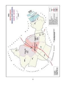
Mangalagiri Mandal Map

Mangalagiri


Villages and Towns  in Mangalagiri Mandal

Name of the VillageAreaHouseHoldsPopulationPincode
Atmakur95514476103522503
Chinakakani1083 16947,040 522508
Chinavadlapudi1042128 433522437
Kaza1818249010,148 522508
Krishnayapalem6344711,560 522502
Kuragallu1434 1232 4340522502
MangalagiriNA28139107,197 522503
Nidamarru1,13116986196522502
Nowlur2091 NANA522233
Nuthakki1,122 40599512522303
Pedavadlapudi949365513076522302
Ramachandrapuram9183711077522303

Demographics

As per the census of 2011, there were 65,356 households residing in the Mangalagiri Mandal.The total population of Mangalagiri  Mandal is 1,36,264. The Mangalagiri Mandal has 33,512 literates.There were 59506 voters in Mangalagiri Mandal.


Name of the VillageTotal PopulationMale PopulationFemale Population0-6 Yr Total Population 0-6 Yr Male Population 0-6 Yr Female Population Total VotersMale VotersFemale Voters 
Atmakur6103 3094 3,009NANANA6388 3166 3222
Chinakakani7,040 3,561 3,479748
389 3594501 2240 2261
Chinavadlapudi433216 21736 23 13321 159 162
Kaza10,148 5,708 4,440955 485 4706027 29703057
Krishnayapalem1,560 724 83614678 681182 562620
Kuragallu4,340 2,156 2,184430 222 2082033 9921041
Mangalagiri107,197 53,301 53,89611,176 5,640 5,53668073 26519 27533
Nidamarru6,196 3,032 3,164567266 3014614 23182296
NowlurNANANANANANA1770 899871
Nuthakki9,512 4,839
4,673624315 3097051 3424 3626
Pedavadlapudi13,076 6,552 6,5241,090 535 5559791 4787 5004
Ramachandrapuram1,077 516 56161 37 24797 383 414

Education

Name of the VillageNumber of SchoolsNumber of Colleges 6-14 Yr ChildrenTotal LiteratesMale LiteratesFemale LiteratesTotal IlliteratesMale IlliteratesFemale IlliteratesLitercay RateIlliteracy Rate
Atmakur5NA1114NANANANANANANANA
Chinakakani3NA6424,384 2,360 2,0242,656 1,201 1,45562.2737.73
ChinavadlapudiNANA29331 16017110256 4676.4423.56
Kaza4NA7186,349 4,003 2,3463,799 1,705 2,09462.5637.44
Krishnayapalem1NA249983484499577 240 33763.0136.99
Kuragallu2NA2022,359 1,337 1,0221,981 819 1,16254.3545.65
MangalagiriNAANANA70,967 38,292 32,67536,230 15,009 21,22166.2033.80
Nidamarru4NA11143,5851,962 1,6232,611 1,070 1,54157.8542.14
Nowlur4NA389NANANANANANANANA
Nuthakki4NA8426,264 3,362 2,9022,972 1,235 1,73765.8531.24
Pedavadlapudi10NA29148,585 4,6523,9334,491 1,900 2,59165.6534.35
RamachandrapuramNANA81672 342 330405 174 23162.3937.60


Administration

Mangalagiri Mandal comes under Guntur parliament constituency and Mangalagiri assembly constituency

In the year 2014 Elections Galla Jaydev elected as the member of parliament(MP) and
Alla Rama Krishna Reddy elected as the member of legislative assembly(MLA).

Agriculture

As per 2001 census,

Name of the VillageArea in HectaresNumber of forest landTotal irrigated areaUnirrigated areaCulturable wasteArea not available for cultivationTotal milk production in the GP (litres in a year)Total egg production (number) 
Atmakur955NA418.44128.29200.00208.00150000010000
Chinakakani1083 0.00524.47274.50 0.00284.007300001800
Chinavadlapudi1042NA159.04469.00 398.1815.78144000300
Kaza18180.00753.93392.55300.00371.006570002760
Krishnayapalem6340.00353.7022.260.00258.0427375012000
Kuragallu1434 0.00222.58655.00300.00
256.00120000 810
MangalagiriNANANANANANANANA
Nidamarru1,1310.0082.15706.58200.00142.00 17520010800
Nowlur2091 NA590.84590.00NA 910.00590.841200
Nuthakki1,122 171.99750.29105.220.0094.5012634000
10800
Pedavadlapudi9490.00794.0017.000.00138.001053000 49185
Ramachandrapuram9180.00747.46100.0048.2822.267812002800

How To Reach

Name of the VillageMangalagiriGunturVijayawadaHow to reach
Atmakur2.926.412.8
Chinakakani3.921.317.8
Chinavadlapudi8.031.418.7
Kaza6.219.218.9
Krishnayapalem7.531.914.0
Kuragallu7.629.321.3
Mangalagiri24.914.9
Nidamarru5.428.622.5
Nowlur5.031.623.6
Nuthakki10.033.014.0
Pedavadlapudi6.529.917.2
Ramachandrapuram12.936.417.9

Geography

 latitude: 16.779027

longitude: 80.124906

Temperature: 36  C/F

Wind: 21 Km/h

Economy

Name of the VillageTotal income (in Rs.'00)Total expenditure (in Rs.'00)
Atmakur953100904400
Chinakakani780174624955
Chinavadlapudi4103141576
Kaza1103659 1131273
Krishnayapalem208307186301
Kuragallu266756395028
Mangalagiri2686624614056234
Nidamarru284188244437
Nowlur19354421935442
NuthakkiNANA
Pedavadlapudi13472751253164
Ramachandrapuram284188244437

Tourism

Mangalagiri is one of the tourist place in Mangalagiri Mandal.

The nearest tourist places are Guntur,Vijayawada,Amaravathi and NagarjunaKonda.

The distance from the Mangalagiri Mandal to Nagarjuna Konda is 120 KM


Map