Categories
Mandal

Amaravathi Mandal

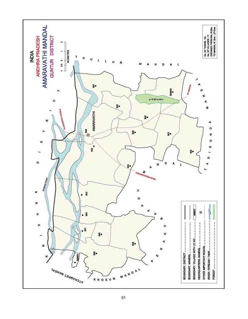
Amaravathi mandal is located in Guntur district of Andhra Pradesh, India. Amaravathi Mandal  is the part of capital region development authority(CRDA).It is 32 km far from the Guntur and 40 Km far from the Vijayawada.The Mandal boundaries are Krishna River, Krosuru Mandal, Pedakurapadu Mandal, Tadikonda Mandal and Thullur Mandal.

Mandal(SubDistrict)Amaravathi
DistrictGuntur
stateAndhra Pradesh
CountryIndia(bharat)
Number Of Villages17
Population66,277
LanguageTelugu
TimeZoneUTC/GMT +5:30, IST

Amaravathi Mandal Map

Amaravathi Mandal


Villages  in Amaravathi Mandal

Name of the VillageAreaHouseHoldsPopulationPincode
Amaravathi1,1703316 13,400522020
Attalur1,5241188 4783522436
Dharanikota3,5481966 7,534 522020
Didugu2,3529203,152 522402
Endroy8777482703522016
Jupudi4635602,422522436
Karlapudi1,19315805,644522016
Lingapuram58210404,064522436
Malladi5726942,582522436
Munugodu1,94610114,011522402
Narukullapadu9417262,335522436
Nemalikallu1,43915966,111 522016
Pedda Madduru4644021400522020
Pondugala758144541522020
PuttipaduNANANANA
Unguturu1,033739 2768522016
Vykuntapuram1,3608723,126522020

Demographics

As per the census of 2011, there were 17502 households residing in the Amaravathi Mandal. The total population of the Amaravathi Mandal is 66,277. The Amaravathi Mandal has 37,507 literates.There were 48600 voters in Amaravathi Mandal.


Name of the VillageTotal PopulationMale PopulationFemale Population0-6 Yr Total Population 0-6 Yr Male Population 0-6 Yr Female Population Total VotersMale VotersFemale Voters 
Amaravathi13,4006,4326,9681,321647674988648695017
Attalur478324062377499 2482513687 1867 1820
Dharanikota7,534 3,734 3,800725
368 3575242 2428 2814
Didugu3,1521,580 1,572336 182 1542216 1140 1076
Endroy2,677 1,338 1,339263 127 1361988 1027961
Jupudi2,422 1,226 1,196310 163 1471743 866877
Karlapudi5,644 2,847 2,797573 2962774418 2211 2207
Lingapuram4,0642,006 2,058480 2452352205 11281077
Malladi2,582 1,247 1,335289 144 1451960 1004 956
Munugodu4,0111,995 2,016481244 2372773 1373 1400
Narukullapadu2,3351,127 1,208238 105 1331763 863 900
Nemalikallu6,111 3,035 3,076NANANA2773 13731400
Pedda Madduru1,400 699 701146 61 851171 593578
Pondugala541 259 28261 27 34330172 158
PuttipaduNANANANANANANANANA
Unguturu2,768 1,369 1,399278 1461322514 1275 1239
Vykuntapuram3,126 1,578 1,548356 186 1702514 1275 1239

Education

Name of the VillageNumber of SchoolsNumber of Colleges 6-14 Yr ChildrenTotal LiteratesMale LiteratesFemale LiteratesTotal IlliteratesMale IlliteratesFemale IlliteratesLitercay RateIlliteracy Rate
Amaravathi8NA17898,617 4,527 4,0904,783 1,905 2,87864.3135.69
Attalur4NA4972657
1536 11212126 870 125655.5544.45
Dharanikota4114064,498 2,551 1,9473,036 1,183 1,85359.7040.30
Didugu2NA2891,512 8466661,640 734 90647.9752.03
Endroy2NA2001,525 836689 1,178 522 65656.9744.00
Jupudi3NA2891,222 7015211,200 52567550.4549.55
Karlapudi2NA2393,165 1,869 1,2962,479 978 1,50156.0843.92
Lingapuram4NA2942,041 1,161 8802,023 8451,17850.2249.78
Malladi6NA5691,372 7716011,210 47673453.1446.86
Munugodu3NA6382,115 1,193 9221,896 802 1,09452.7347.27
Narukullapadu1NA3121,287 7055821,048 422 62655.1244.88
Nemalikallu3NA331NANANANANANANANA
Pedda Madduru1NA174794 439 355606 260 34656.7143.29
PondugalaNANANA270 145 125271 114 15749.9150.09
PuttipaduNANANANANANANANANANANA
Unguturu2NA2401,571 854 7171,197 51568256.7643.24
Vykuntapuram2NA3281,619 9326871,507 646 86151.7948.21


Administration

Amaravathi Mandal comes under Narasaraopeta parliament constituency and Pedakurapadu assembly constituency

In the year 2014 Elections Rayapati Sambasiva Rao elected as the member of parliament(MP) and Kommalapati Sreedhar elected as the member of legislative assembly(MLA)

Agriculture

As per 2001 census,

Name of the VillageArea in HectaresNumber of forest landTotal irrigated areaUnirrigated areaCulturable wasteArea not available for cultivationTotal milk production in the GP (litres in a year)Total egg production (number) 
Amaravathi1,1700.00159.00588.00125.00298.004750005510000
Attalur1,5240.00244.001026.00208.0046.006400001458
Dharanikota3,5480.0060.002006.00141.001341.003253203169105
Didugu2,3520.0011.001351.00307.00683.004587843810
Endroy8770.00153.00495.00176.0053.001200057500
Jupudi4630.0038.00394.006.0025.00270000827070
Karlapudi1,193167.0051.00819.0089.0067.00471100536
Lingapuram5820.0078.00451.0017.0036.00380216580
Malladi5720.004.00560.005.003.00480600137500
Munugodu1,9460.00134.001215.0041.00556.004860005400
Narukullapadu9410.0087.00529.00282.0043.007740008385
Nemalikallu1,4390.00121.00663.00387.00268.00690023750
Pedda Madduru46458.0073.00284.0048.001.00215205420
Pondugala7580.007.00248.00187.00316.00NANA
PuttipaduNANANANANANANANA
Unguturu1,0330.0084.00671.00201.0077.00172800
9000
Vykuntapuram1,360263.00146.00551.00273.00127.006181003205

How To Reach

Name of the VillagePedakurapaduAmaravathiGunturVijayawadaHow to reach
Amaravathi17.4
Attalur7.915.247.454.8
Dharanikota14.52.934.442.4
Didugu14.46.939.246.5
Endroy20.17.52538.6
Jupudi111244.251.6
Karlapudi29.612.722.538.9
Lingapuram12.2637.545.5
Malladi10.642.850.2
Munugodu13.613.946.253.5
Narukullapadu19.34.027.343.0
Nemalikallu13.513.726.947.6
Pedda Madduru23.45.729.534.1
Pondugala18.312.244.551.8
PuttipaduNANANANA
Unguturu16.210.524.944.3
Vykuntapuram26.79.733.430.3

Geography

 latitude: 16.779027

longitude: 80.124906

Temperature: 36  C/F

Wind: 21 Km/h

Tourism

Amaravathi is one of the tourist places in Amaravathi Mandal.

The nearest tourist places are Guntur, Vijayawada, Mangalagiri and NagarjunaKonda.

The distance from the Amaravathi Mandal to Nagarjuna Konda is 120 KM

Map


Categories
Mandal

Atchampeta Mandal

Atchampeta mandal is located in Guntur district of Andhra Pradesh, India. Atchampeta mandal  is the part of capital region development authority(CRDA).It is 63.5 km far from the Guntur and 70.9 Km far from the Vijayawada.The Mandal boundaries are Bellamkonda Mandal, Krosuru Mandal, Amaravathi Mandal and Krishna District.

Mandal(SubDistrict)Atchampeta
DistrictGuntur
stateAndhra Pradesh
CountryIndia(bharat)
Number Of Villages18
Population58,447
LanguageTelugu
TimeZoneUTC/GMT +5:30, IST

Atchampeta Mandal Map

Atchampeta Mandal

Villages  in Atchampeta Mandal

Name of the VillageAreaHouseHoldsPopulationPincode
Ambadipudi935239904 522265
Challagariga2883361,490 522409
Chamarru2,720300612,232522409
Chigurupadu1,1357142,706 524421
Chintapalli1,64212504,547 524421
Ginjupalli437253949 522409
Kastala1,6335722,292 522410
Kogantivaripalem561223916522409
Konduru1,03110144,028522410
Konur9298433,301 522410
Madipadu 2183821,533522409
Madipaduseri632196900 522410
Mittapalem8183131,225 522421
Oravakallu1,369NANA522409
Pedapalem6389583,916 522410
Taduvoy4214241,702 522409
Tallacheruvu1,16817526,213 522409
Velpuru2,54212894,690 522410

Demographics

As per the census of 2011, there were 15068 households residing in the Atchampeta mandal. The total population of the Atchampeta mandal is 58,447. The Atchampeta mandal has 27,585 literates.There were 37871 voters in Atchampeta mandal.


Name of the VillageTotal PopulationMale PopulationFemale Population0-6 Yr Total Population 0-6 Yr Male Population 0-6 Yr Female Population Total VotersMale VotersFemale Voters 
Ambadipudi904 441 4631186157684 331353239
Challagariga1,490 736754208 104 1041087551536336
Chamarru12,232 6,456 5,7761,320 684 6368698 4291 44073006
Chigurupadu2,706 1,345 1,361 302 149 1532166 10801086714
Chintapalli4,547 2,272 2,275 501 243 2581513 779 7341250
Ginjupalli949 470 47914171 70648 319329253
Kastala2,292 1,153 1,139309 149 1601567 802765572
Kogantivaripalem916 4774391085850678 336 342223
Konduru4,028 1,998 2,030597 284 3133066 1560 15061014
Konur3,301 1,680 1,621438240 1982375 1177 1198843
Madipadu 1,533789 744170 91 791732 879 853382
Madipaduseri900 469 43111156 55NANANA196
Mittapalem1,225 611 614189 9990852 409 443313
OravakalluNANANANANANA1029501 528NA
Pedapalem3,916 1,987 1,929431 229 202316115921569958
Taduvoy1,702 855 847231124 1071166 593 573424
Tallacheruvu6,213 3,151 3,062600 3212793805 1865 19401752
Velpuru4,690 2,341 2,349430 235 1953644 1817 18271289

Education

Name of the VillageNumber of SchoolsNumber of Colleges 6-14 Yr ChildrenTotal LiteratesMale LiteratesFemale LiteratesTotal IlliteratesMale IlliteratesFemale IlliteratesLitercay RateIlliteracy Rate
Ambadipudi1NA59399 231 168505 210 29544.1455.86
Challagariga2NA188636 375 261854361 49342.6857.32
ChamarruNANANA6,848 4,170 2,6785,384 2,286 3,09855.9844.02
Chigurupadu4NA4511,160 712 4481,546 633 91342.8757.13
Chintapalli2NA2302,128 1,311 817 2,419 9611,45846.8053.20
GinjupalliNANANA329 207 122620 26335734.6765.33
Kastala2NA3891,0666224441,226 531 69546.5153.49
Kogantivaripalem1NA60492 274218424 20322153.7146.29
Konduru6NA5681,264 803 4612,764 1,195 1,56931.3868.62
Konur2NA4331,394 818 5761,907 862 1,04542.2357.77
Madipadu 2NA280796 478 318737 311 42651.9248.08
MadipaduseriNANANA389244 145511 225 28643.2256.78
Mittapalem1NA130455265 190770 34642437.1462.86
Oravakallu1NA125NANANANANANANANA
Pedapalem5NA4481,821 1,041 7802,095 946 1,14946.5053.50
Taduvoy4NA239726 428 298976 427 54942.6657.34
Tallacheruvu5NA6293,127 1,786 1,3413,086 1,365 1,72150.3349.67
Velpuru4NA6382,310 1,284 1,0262,380 1,057 1,32349.2550.75


Administration

Atchampeta Mandal comes under Narasaraopeta parliament constituency and Pedakurapadu assembly constituency
In the year 2014 Elections Rayapati Sambasiva Rao  elected as the member of parliament(MP) and Kommalapati Sreedhar elected as the member of legislative assembly(MLA)

Agriculture

As per 2001 census,

Name of the VillageArea in HectaresNumber of forest landTotal irrigated areaUnirrigated areaCulturable wasteArea not available for cultivationTotal milk production in the GP (litres in a year)Total egg production (number) 
Ambadipudi9350.0077.00842.000.0016.001153008208
Challagariga28862.0020.00185.000.0021.0026168420784
Chamarru2,7200.00460.00594.00531.001135.00NANA
Chigurupadu1,1350.0071.00933.000.00131.0049157416008
Chintapalli1,6421186.002.00416.000.0038.00466422
21768
Ginjupalli437162.000.00257.000.0018.00NANA
Kastala1,6330.0055.00500.000.001078.0021266412768
Kogantivaripalem5610.004.00322.000.00235.00120NA
Konduru1,031421.00362.00248.000.000.00113423442504
Konur9290.0012.00449.000.00468.00NANA
Madipadu 2180.000.00198.000.0020.0093327660744
Madipaduseri632162.000.00229.0011.00229.00NANA
Mittapalem81882.00215.00346.000.00175.001919466384
Oravakallu1,3690.0046.00633.000.00690.008544150624
Pedapalem6380.00256.00303.000.0079.0057375030384
Taduvoy4210.5614.00191.0040.00175.0073422621528
Tallacheruvu1,16881.0051.00986.0029.0021.0048607835184
Velpuru2,5420.0087.001192.000.001263.0066055227456

How To Reach

Name of the VillageAtchampetaGunturVijayawadaHow to reach
Ambadipudi16.660.067.4
Challagariga18.781.890.8
Chamarru750M63.972.9
Chigurupadu3.161.568.9
Chintapalli8.872.080.9
Ginjupalli22.185.384.9
Kastala13.355.763.0
Kogantivaripalem6.153.768.3
Konduru21.764.177.6
Konur10.4 56.864.2
Madipadu 28.590.692.9
Madipaduseri23.4 95.593.6
Mittapalem 23.065.279.2
OravakalluNANANA
Pedapalem5.5 59.571.8
Taduvoy14.476.586.5
Tallacheruvu 5.2 67.177.1
Velpuru6.856.169.1

Geography 

 latitude: 16.779027

longitude: 80.124906

Temperature: 36  C/F

Wind: 21 Km/h

Tourism

The nearest tourist places are Amaravathi, Guntur, Vijayawada, Mangalagiri and NagarjunaKonda.

The distance from Atchampeta Mandal to Amaravathi is 31.2 Km

and the distance from the Atchampeta Mandal to Nagarjuna Konda is 120 KM

Map

Categories
Village

Ramachandrapuram, Guntur District, Andhra Pradesh

Ramachandrapuram is one of the village in Mangalagiri Mandal, located in Guntur district of Andhra Pradesh, India. The total geographical area of the Ramachandrapuram is 918 hectares. Ramachandrapuram is the part of capital region development authority(CRDA). It is 36.4 km far from the Guntur. The distance from Vijayawada  to Ramachandrapuram is 17.9 km.

VillageRamachandrapuram
Mandal(SubDistrict)Mangalagiri
DistrictGuntur
stateAndhra Pradesh
CountryIndia(bharat)
Population1,077
LanguageTelugu
TimeZoneUTC/GMT +5:30, IST
Telephone Code086452
Pin code522305


Agriculture

Agriculture is the major occupation for the people. The area useful for farming is 747.46 hectares

Total irrigated area 747.46 hectares

Unirrigated area 100.00 hectares

Area not available for cultivation 22.26 hectares

Livestock

Total milk production 781200 liters/Year

Total egg production in a year 2800

Demographics

As per the census of 2011, there were 371 households residing in the  village. The total population of the village is 1,077. The village Ramachandrapuram have 672 literates.There were 797 voters in Ramachandrapuram.

Total PopulationMale PopulationFemale Population
Population1,077 516 561
0-6 Years Population61 37 24
Literates672 342 330
Illiterates405 174231
Voters797 383414


How  To Reach

Road 

It is 12.9 km far from the Mangalagiri. People can reach from Mangalagiri to Ramachandrapuram by private transport like Auto etc. The nearest town to Ramachandrapuram is Mangalagiri.

The village is 36.4 km far from the Guntur district. People reach from Guntur to Ramachandrapuram through the bus. APSRTC provides the bus facility from all major city to Ramachandrapuram.

The distance from Vijayawada  to Ramachandrapuram is 17.9 km.

Railways 

There is no railway station in Ramachandrapuram the nearest railway station  is Mangalagiri.

People have to reach to Mangalagiri by train and from Mangalagiri people have to reach by road.

Air 

The nearest domestic airport is Vijayawada airport.

And international Airport is Hyderabad and Chennai.

Geography

 latitude: 16.779027

longitude: 80.124906

Temperature: 36  C/F

Wind: 21 Km/h

Economy

As per 2001 Census the Income and Expenditure of the village

Total Income – 284188

Total Expenditure – 244437

Education

The nearest schools are

Gayatri Vidya Niketan – Ramachandra Palem Road, Nutakki

Kumar Master School – Nutakki

Chintala Badi – Ramachandra Palem Road, Nutakki

Temples

The temples in Ramachandrapuram

Ramalayam temple – Ramachandrapuram


Banks

The nearest banks are

Bank Of India – Zilla Parishad road, Nutakki

STATE BANK OF INDIA – Near D NO 5-30, main road, Nutakki

The NUTAKKI CO-OPERATIVE SOCIETY BANK – RamachandraPuram Road, Nutakki


Administration

Ramachandrapuram comes under Guntur parliament constituency and Mangalagiri assembly consistency

In the year 2014 Elections Galla Jaydev elected as the member of parliament(MP) and
Alla Rama Krishna Reddy elected as the member of legislative assembly(MLA)

President(Sarpanch) of Ramachandrapuram is yenumula sambrajyam

The Mandal Revenue Office (MRO) for Ramachandrapuram is the Mangalagiri

The Nearest RTO office is located in Mangalagiri.

Tourism

Nearest tourist places are Chinakakani, Amaravathi, Vijayawada and Guntur

Distance

Distance between Chinakakani to Ramachandrapuram  is 15.5 km

Distance between Amaravathi to Ramachandrapuram is 47.2 km

Distance between Vijayawada to Ramachandrapuram is 17.9 km

and the distance between Guntur to Ramachandrapuram is 36.4 km

Boundaries

Ramachandrapuram boundaries are Veerlapalem, Chirravur, Revendrapadu and Nutakki

Maps

Categories
Village

Nowlur

Nowlur is one of the village in Mangalagiri Mandal, located in Guntur district of Andhra Pradesh, India. The total geographical area of the Nowlur is 2091 hectares. Nowlur is the part of capital region development authority(CRDA). It is 31.6 km far from the Guntur. The distance from Vijayawada  to Nowlur is 23.6 km.

VillageNowlur
Mandal(SubDistrict)Mangalagiri
DistrictGuntur
stateAndhra Pradesh
CountryIndia(bharat)
Population
LanguageTelugu
TimeZoneUTC/GMT +5:30, IST
Telephone Code086452
Pin code522503

Agriculture

Agriculture is the major occupation for the people. The area useful for farming is 590.84 hectares

Total irrigated area 590.84 hectares

Unirrigated area 590.00 hectares

Area not available for cultivation 910.00 hectares

Livestock

Total milk production 590.84 liters/Year

Total egg production in a year 1200

Demographics

As per the census of 2011, there were XXXX households residing in the Nowlur  village. The total population of the village is XXXX. The village Nowlur has XXXX literates.There were 1770 voters in Nowlur.

Total PopulationMale PopulationFemale Population
Population
0-6 Years Population
Literates
Illiterates
Voters1770 899871

How  To Reach

Road 

It is 5.0 km far from the Mangalagiri. People can reach from Mangalagiri to Nowlur by private transport like Auto etc. The nearest town to Nowlur is Mangalagiri.

The village is 31.6 km far from the Guntur district. People reach from Guntur to Nowlur through the bus. APSRTC provides the bus facility from all major city to Nowlur.

The distance from Vijayawada  to Nowlur is 23.6 km.

Railways 

There is no railway station in Nowlur the nearest railway station  is Mangalagiri.

People have to reach to Mangalagiri by train and from Mangalagiri people have to reach by road.

Air 

The nearest domestic airport is Vijayawada airport.

And international Airport is Hyderabad and Chennai.

Geography

 latitude: 16.779027

longitude: 80.124906

Temperature: 36  C/F

Wind: 21 Km/h

Economy

As per 2001 Census the Income and Expenditure of the village

Total Income – 1935442 Rs

Total Expenditure – 1935442 Rs

Education

There is one  Upper Primary and 3 Primary schools in Nowlur

Temples

The nearest temples are

Panakala Lakshmi Narasimha Swamy Temple – Main Bazar, Temple Road, Kothapet, Mangalagiri

Gandalayam – Mangalagiri

Ganesh Temple – NH 5, Mangalagiri

Durgadevi temple – Indira Nagar Rd, Mangalagiri

Sri Venkateswara Swamy Temple – Ghat Rd, Mangalagiri

Banks

The nearest banks are

Corporation Bank – 1-649, Trunk Rd, G.T Road, Near Bungalow, Kothapet, Baptist Pet, Mangalagiri,

Indian Bank – Door No. 10/1/11, Gowtham Buddha Road, New Bank Colony, Mangalagiri

State Bank Of India – G.T. Road, Near Market Yard, Beside Vijaya Deluxe, Kothapet, Mangalagiri

State Bank of Hyderabad – Bhargava Peta, Mangalagiri

HDFC Bank Branch – 1-437 Ground Floor Kothapeta, G T Road, Mangalagiri

IIFL – India Infoline Finance Limited – Trunk Road,New Bank Colony, Mangalagiri

FEDBANK FINANCIAL SERVICES LIMITED – Dr.No: 6-172, First Floor, Mangalagiri

UCO Bank – 7-547, Trunk Rd, Near Old Bus Stand, New Bank Colony, Mangalagiri

Andhra Bank – Mangalagiri Branch,7-13, Trunk Rd, G. T. Road, Near Andhra Bank, Beside Venkateswara hall, NewBank Colony, Mangalagiri

Life Insurance Corporation Of India – Jyothi Electronics Building, Trunk Road, Kothapet,Mangalagiri


Administration

Nowlur comes under Guntur parliament constituency and Mangalagiri assembly consistency

In the year 2014 Elections Galla Jaydev elected as the member of parliament(MP) and
Alla Rama Krishna Reddy elected as the member of legislative assembly(MLA)

President(Sarpanch) of Nowlur is Banavath. Balaji Naik

The Mandal Revenue Office (MRO) for Nowlur is the Mangalagiri

The Nearest RTO office is located in Mangalagiri.

Tourism

Nearest tourist places are Chinakakani, Amaravathi, Vijayawada and Guntur

Distance

Distance between Chinakakani to Nowlur  is 10.7 km

Distance between Amaravathi to Nowlur is 28.9 km

Distance between Vijayawada to Nowlur  is 23.6 km

and the distance between Guntur to Nowlur is 31.6 km

Boundaries

Nowlur boundaries are Mangalagiri, Kuragallu, Nidamarru and Neerukonda

Maps

Categories
Village

Pedavadlapudi

Pedavadlapudi is one of the village in Mangalagiri Mandal, located in Guntur district of Andhra Pradesh, India. The total geographical area of the Pedavadlapudi is 949 hectares. Pedavadlapudi is the part of capital region development authority(CRDA). It is 29.9 km far from the Guntur. The distance from Vijayawada  to Pedavadlapudi is 17.2 km.

VillagePedavadlapudi
Mandal(SubDistrict)Mangalagiri
DistrictGuntur
stateAndhra Pradesh
CountryIndia(bharat)
Population13076
LanguageTelugu
TimeZoneUTC/GMT +5:30, IST
Telephone Code086452
Pin code522503

Agriculture

Agriculture is the major occupation for the people. The area useful for farming is 794.00 hectares

Total irrigated area 794.00 hectares

Unirrigated area 17.00 hectares

Area not available for cultivation 138.00 hectares

Livestock

Total milk production 1053000 liters/Year

Total egg production in a year 49185

Demographics

As per the census of 2011, there were 3655 households residing in the Pedavadlapudi  village. The total population of the village is 13076. The village Pedavadlapudi have 8585 literates.There were 9791 voters in Pedavadlapudi.

Total PopulationMale PopulationFemale Population
Population13,076 6,552 6,524
0-6 Years Population1,090 535 555
Literates8,585 4,652 3,933
Illiterates4,491 1,900 2,591
Voters9791 47875004

How  To Reach

Road 

It is 6.5 km far from the Mangalagiri. People can reach from Mangalagiri to Pedavadlapudi by private transport like Auto etc. The nearest town to Pedavadlapudi is Mangalagiri.

The village is 29.9 km far from the Guntur district. People reach from Guntur to Pedavadlapudi through the bus. APSRTC provides the bus facility from all major city to Pedavadlapudi.

The distance from Vijayawada  to Pedavadlapudi is 17.2 km.

Railways 

There is  railway station in Pedavadlapudi. People have to reach to Pedavadlapudi by train .

Air 

The nearest domestic airport is Vijayawada airport.

And international Airport is Hyderabad and Chennai.

Geography 

 latitude: 16.779027

longitude: 80.124906

Temperature: 36  C/F

Wind: 21 Km/h

Economy

As per 2001 Census the Income and Expenditure of the village

Total Income – 1347275

Total Expenditure – 1253164

Education

ATPM High School – Pedavadlapudi

Primary School – Pedavadlapudi

Urdu School – Pedavadlapudi

MPP School – Kotha Palem, Pedavadlapudi

Temples

The temples in Pedavadlapudi

Brahmamgari Temple – Pedavadlapudi

Sai Baba Temple – Pedavadlapudi

Shivalayam – Pedavadlapudi

Hanuman Temple – Kotha Palem, Pedavadlapudi

Nagendra Swamy Putta – Kotha Palem,Pedavadlapudi

Durga Matha Temple – Kotha Palem, Pedavadlapudi

Church

Luthren Church – Pedavadlapudi

Mosque

Noorani Masjid – Pedavadlapudi


Banks

The banks in Pedavadlapudi

Bank Of India – Pedavadlapudi, Andhra Pradesh 522302


Administration

Pedavadlapudi comes under Guntur parliament constituency and Mangalagiri assembly consistency

In the year 2014 Elections Galla Jaydev elected as the member of parliament(MP) and
Alla Rama Krishna Reddy elected as the member of legislative assembly(MLA)

President(Sarpanch) of Pedavadlapudi is Chittibomma. Venkateswara Rao

The Mandal Revenue Office (MRO) for Pedavadlapudi is the Mangalagiri

The Nearest RTO office is located in Mangalagiri.

Tourism

Nearest tourist places are Chinakakani, Amaravathi, Vijayawada and Guntur

Distance

Distance between Chinakakani to Pedavadlapudi  is 9.1 km

Distance between Amaravathi to Pedavadlapudi  is 43.0 km

Distance between Vijayawada to Pedavadlapudi  is 17.2 km

and the distance between Guntur to Pedavadlapudi is 29.9 km

Beverages

Hindustan Coca-Cola. Beverages Pvt. Ltd. – Pedavadlapudi, Andhra Pradesh 522503

Boundaries

Pedavadlapudi boundaries are Ippatam, Chiluvuru, Tummapudi and Vaddeswaram

Maps

Categories
Village

Nidamarru, Guntur District, Andhra Pradesh

Nidamarru is one of the village in Mangalagiri Mandal, located in Guntur district of Andhra Pradesh, India. The total geographical area of the Nidamarru is 1,131 hectares. Nidamarru is the part of capital region development authority(CRDA). It is 28.6 km far from the Guntur. The distance from Vijayawada  to Nidamarru is 22.5 km.

VillageNidamarru
Mandal(SubDistrict)Mangalagiri
DistrictGuntur
stateAndhra Pradesh
CountryIndia(bharat)
Population6,196
LanguageTelugu
TimeZoneUTC/GMT +5:30, IST
Telephone Code086452
Pin code522503

Agriculture

Agriculture is the major occupation for the people. The area useful for farming is 82.15 hectares

Total irrigated area 82.15 hectares

Unirrigated area 706.58 hectares

Area not available for cultivation 142.00 hectares

Livestock

Total milk production 175200 liters/Year

Total egg production in a year 10800

Demographics

As per the census of 2011, there were 1698 households residing in the Nidamarru  village. The total population of the village is 6,196. The village Nidamarru have 3,585 literates.There were 4614 voters in Nidamarru.

Total PopulationMale PopulationFemale Population
Population6,196 3,032 3,164
0-6 Years Population567 266 301
Literates3,585 1,962 1,623
Illiterates2,611 1,070 1,541
Voters4614 23182296


How  To Reach 

Road 

It is 5.4 km far from the Mangalagiri. People can reach from Mangalagiri to Nidamarru by private transport like Auto etc. The nearest town to Nidamarru is Mangalagiri.

The village is 28.6 km far from the Guntur district. People reach from Guntur to Nidamarru through the bus. APSRTC provides the bus facility from all major city to Nidamarru.

The distance from Vijayawada  to Nidamarru is 22.5 km.

Railways 

There is no railway station in Nidamarru the nearest railway station  is Mangalagiri.

People have to reach to Mangalagiri by train and from Mangalagiri people have to reach by road.

Air 

The nearest domestic airport is Vijayawada airport.

And international Airport is Hyderabad and Chennai.

Geography 

 latitude: 16.779027

longitude: 80.124906

Temperature: 36  C/F

Wind: 21 Km/h

Economy

As per 2001 Census the Income and Expenditure of the village

Total Income – 284188

Total Expenditure – 244437

Education

There is one  Upper Primary school in Nidamarru

Temples

The nearest temples are

Panakala Lakshmi Narasimha Swamy Temple – Main Bazar, Temple Road, Kothapet,Mangalagiri

Gandalayam – Mangalagiri

Ganesh Temple – NH 5, Mangalagiri

Durgadevi temple – Indira Nagar Rd , Mangalagiri

Sri Venkateswara Swamy Temple – Ghat Rd, Mangalagiri

Banks

The nearest banks are

Corporation Bank – 1-649, Trunk Rd, G.T Road ,Near Bungalow, Kothapet, Baptist Pet, Mangalagiri,

Indian Bank – Door No. 10/1/11,Gowtham Buddha Road,New Bank Colony,Mangalagiri

State Bank Of India – G.T. Road, Near Market Yard, Beside Vijaya Deluxe, Kothapet,Mangalagiri

State Bank of Hyderabad – Bhargava Peta, Mangalagiri

HDFC Bank Branch – 1-437 Ground Floor Kothapeta, G T Road, Mangalagiri

IIFL – India Infoline Finance Limited – Trunk Road,New Bank Colony, Mangalagiri

FEDBANK FINANCIAL SERVICES LIMITED – Dr.No: 6-172, First Floor, Mangalagiri

UCO Bank – 7-547, Trunk Rd, Near Old Bus Stand, New Bank Colony, Mangalagiri

Andhra Bank – Mangalagiri Branch, 7-13, Trunk Rd, G. T. Road, Near Andhra Bank, Beside Venkateswara hall, NewBank Colony, Mangalagiri

Life Insurance Corporation Of India – Jyothi Electronics Building, Trunk Road, Kothapet, Mangalagiri

Administration

Nidamarru comes under Guntur parliament constituency and Mangalagiri assembly consistency

In the year 2014 Elections Galla Jaydev elected as the member of parliament(MP) and
Alla Rama Krishna Reddy elected as the member of legislative assembly(MLA)

President(Sarpanch) of Nidamarru is Mandepudi. Manemma

The Mandal Revenue Office (MRO) for Nidamarru is the Mangalagiri

The Nearest RTO office is located in Mangalagiri.

Tourism

Nearest tourist places are Chinakakani, Amaravathi, Vijayawada and Guntur

Distance

Distance between Chinakakani to Nidamarru  is 4.9 km

Distance between Amaravathi to Nidamarru  is 29.6 km

Distance between Vijayawada to Nidamarru  is 22.5 km

and the distance between Guntur to Nidamarru is 28.6 km

Boundaries

Nidamarru boundaries are Mangalagiri, Nowluru, Nidamarru and Penumaka

Maps

Categories
Town

Mangalagiri

Mangalagiri is one of the Town in Mangalagiri Mandal, located in Guntur district of Andhra Pradesh, India. Mangalagiri is known for its celebrated Sri Panakala Lakshmi Narasimhaswamy temple situated on the slope top. The word Mangalagiri reffers to ‘The blessed hill’.It is additionally said that there are 8 critical Mahakshetrams (consecrated spots) in India.Mangalagiri is one among them. Mangalagiri is the part of capital region development authority(CRDA). It is 24.9 km far from the Guntur. The distance from Vijayawada  to Mangalagiri is 14.9 km.

VillageMangalagiri
Mandal(SubDistrict)Mangalagiri
DistrictGuntur
stateAndhra Pradesh
CountryIndia(bharat)
Population107,197
LanguageTelugu
TimeZoneUTC/GMT +5:30, IST
Telephone Code086452
Pin code522503

Etomology

The Mangalagiri town has gotten from its unique name “TOTADRI”. The Mangalagiri signifies that Mangala is Subham and GIRI implies a Hill i.e., a slope which offers subham to the individuals furthermore there is a story that the preeminent Lord to all subhams are Vigneswara and the state of the Hill is similar to head of Elephant/Vigneswara. Thus, it is called as Mangalagiri.


Demographics

As per the census of 2011, there were 28139 households residing in the Mangalagiri  village. The total population of the village is 107,197. The village Mangalagiri has 70,967 literates.There were 68070  voters in Mangalagiri.

Total PopulationMale PopulationFemale Population
Population107,197 53,301 53,896
0-6 Years Population11,176 5,640 5,536
Literates70,967 38,292 32,675
Illiterates36,230 15,009 21,221
Voters680732651927533


Occupation

Handweaver weaving is the principle control of individuals living in Mangalagiri very nearly half of individuals living in this area rely on the Cotton industry

How  To Reach

Road 

The town is 24.9 km far from the Guntur district. People reach from Guntur to Mangalagiri, Andhra Pradesh through the bus. APSRTC provides the bus facility from all major city to Mangalagiri, Andhra Pradesh.

The distance from Vijayawada  to Mangalagiri, Andhra Pradesh is 14.9 km.

Railways

There is a railway station in Mangalagiri.People have to reach to Mangalagiri by train.

Air 

The nearest domestic airport is Vijayawada airport.

And international Airport is Hyderabad and Chennai.

Geography

 latitude: 16.779027

longitude: 80.124906

Temperature: 36  C/F

Wind: 21 Km/h

Economy

As per 2001 Census the Income and Expenditure of the village

Total Income – 26866246

Total Expenditure – 14056234

Education

Schools

New Kennedy High School -1-659, Gowtham Buddha Road, G.T. Road, Near Bungalow, Kothapet, Mangalagiri

Don Bosco Prem Niwas  – Guntur Road, Mangalagiri

Sri N.V.S Vidya Niketan – Mangalagiri

S.L.M.Chaitanya High School – Atmakuru Rd, Mangalagiri

Nirmala E.M High school – Mangalagiri

Narayana E – Techno School – No. 4-364, Sharaf Bazar, Mangalagiri

Indian Digital Schools – Shop No. 7-455, APSRTC Depot Rd, G.B. Road, Beside NIR School, Beside RTC

Depot, Road, Autonagar, Mangalagiri

Arvinda Model School -Nidamarru Rd, Backside Of Indian Oil Petrol Bunk, Near Old Bus Stand, New Bank Colony, Mangalagiri

Gretnaltes School –  Rajiv Gruhakalpa Road, National Highway Road, Near Kanakadurga Alayam, Markandeya Colony,  Mangalagiri

Ravindra Bharati highschool – Tenali Rd, Mangalagiri

St. Francis English Medium School – 1st Floor, Trunk Rd, Gowtham Bada Road, SBI Main Branch, Near Urvashi Theatre, Bhargava Peta, Mangalagiri

Sri Sai Apex School – Trunk Road, Main Bazar, Mangalagiri

Sri Satya Sai Vidyaniketan – Shop No. 1-136, Kothapeta Rd, Kothapet, Mangalagiri

Colleges

Narayana Junior College – 7-154, 1st Floor, Lava Kumar Complex, Tenali Rd, Bhargava Peta, Mangalagiri

 V.T.J.M & I.V.T.R Degree College – Mangalagiri
Nirmala Junior College – Shop No. 2-239, Kothapeta Rd, Kothapeta, Mangalagiri
CK Jr College – Mangalagiri

Temples

The temples in Mangalagiri

Panakala Lakshmi Narasimha Swamy Temple – Main Bazar, Temple Road, Kothapet,Mangalagiri

Gandalayam – Mangalagiri

Ganesh Temple – NH 5, Mangalagiri

Durgadevi temple – Indira Nagar Rd , Mangalagiri

Sri Venkateswara Swamy Temple – Ghat Rd, Mangalagiri

Church

Saint Paul’s Lutheran Church – Maseed Rd, Opp. Netaji Complex, New Bank Colony, Mangalagiri

Krupa Prardhana Dhyana Mandiram – Mangalagiri

The Apostolic Church – Mangalagiri

Mosques

Eidgah Masjid – Mangalagiri

Abubakar Siddique Masjid – New Bank Colony, Mangalagiri

Husane Masjid – Main Bazar, Shasa Bazar, Flower Market Centre, New Bank Colony,Mangalagiri

Banks

The  banks in Mangalagiri are

Bank NameIFSC CodeMICR codeAddress
Corporation BankCORP0001809
5200173021-649, Trunk Rd, G.T Road ,Near Bungalow, Kothapet, Baptist Pet, Mangalagiri,

Andhra Pradesh 522503
Indian BankIDIB000M243
520019302Door No. 10/1/11,Gowtham Buddha Road,New Bank Colony,Mangalagiri, Andhra Pradesh 522503
State Bank Of IndiaSBIN0001011
520002302G.T. Road, Near Market Yard, Beside Vijaya Deluxe, Kothapet,Mangalagiri,Andhra Pradesh 522503
State Bank of Hyderabad SBHY0021130
NABhargava Peta, Mangalagiri, Andhra Pradesh 522503
HDFC Bank HDFC0002704
520240302 1-437 Ground Floor Kothapeta, G T Road, Mangalagiri, Andhra Pradesh 522503
UCO BankUCBA0002541
5220285037-547, Trunk Rd,Near Old Bus Stand, New Bank Colony,Mangalagiri, Andhra Pradesh 522503
Andhra BankANDB0000366
520011302Mangalagiri Branch ,7-13, Trunk Rd, G. T. Road, Near Andhra Bank, Beside Venkateswara hall, NewBank Colony, Mangalagiri, Andhra Pradesh 522503
The Andhra Pradesh State Cooperative Bank LimitedAPBL0007021
NAMangalagiri 522503
Karur Vysya BankKVBL0004846
NA"7-402,S V Complex,Gowtham Buddha Road,Mangalagiri,Guntur Dt,Ap-522503
Laxmi Vilas BankLAVB0000476
NADoor No 7-380/A, Psr Bavan, Mangalagiri Main Road,Mangalagiri

Union Bank Of IndiaUBIN0564435 520026302Door No 1 -643 Old G T Road Main Road Mangalagiri Pin Code -522503


Oriental Bank Of CommerceORBC0102124
NAD.No 8-711, Main Bazar, Mangalagiri, Guntur


Bank Of BarodaBARB0MANGUN

NA"Opp Rtc Bus Stand Temple Road Main Road Mangalagiri Guntur Andhra Pradesh 522503
"

Administration

Mangalagiri comes under Guntur parliament constituency and Mangalagiri assembly consistency

In the year 2014 Elections Galla Jaydev elected as the member of parliament(MP) and
Alla Rama Krishna Reddy elected as the member of legislative assembly(MLA)

The Mandal Revenue Office (MRO) is located in Mangalagiri

The RTO office is located in Mangalagiri.

Tourism

Nearest tourist places are Chinakakani,  Amaravathi, Guntur and Vijayawada.

Distance

Distance between Chinakakani to Mangalagiri  is 4.0 km

Distance between Amaravathi to Mangalagiri  is 36.6 km

Distance between Vijayawada to Managalagiri  is 14.9 km

and the distance between Guntur to Mangalari is 24.9 km

Boundaries

Mangalagiri boundaries are Vaddeswaram, Kuragallu, Chinakakani and Nidamarru

Maps

Categories
Village

Kuragallu

Kuragallu is one of the village in Mangalagiri Mandal, located in Guntur district of Andhra Pradesh, India. The total geographical area of the Kuragallu is 1434 hectares. Kuragallu is the part of capital region development authority(CRDA). It is 29.3 km far from the Guntur. The distance from Vijayawada  to Kuragallu is 21.3 km.

VillageKuragallu
Mandal(SubDistrict)Mangalagiri
DistrictGuntur
stateAndhra Pradesh
CountryIndia(bharat)
Population4340
LanguageTelugu
TimeZoneUTC/GMT +5:30, IST
Telephone Code086452
Pin code522503

Agriculture

Agriculture is the major occupation for the people. The area useful for farming is 222.58 hectares

Total irrigated area 222.58 hectares

Unirrigated area 655.00 hectares

Area not available for cultivation 256.00 hectares

Livestock

Total milk production 120000 liters/Year

Total egg production in a year 810

Demographics

As per the census of 2011, there were 1232 households residing in the Kuragallu  village. The total population of the village is 4,340. The village Kuragallu have 2,359 literates.There were 2,033  voters in Kuragallu.

Total PopulationMale PopulationFemale Population
Population4,340 2,156 2,184
0-6 Years Population430 222 208
Literates2,359 1,337 1,022
Illiterates1,981819 1,162
Voters20339921041

How  To Reach

Road

It is 7.6 km far from the Mangalagiri. People can reach from Mangalagiri to Kuragallu  by private transport like Auto etc. The nearest town to Kuragallu, Andhra Pradesh is Mangalagiri.

The village is 29.3 km far from the Guntur district. People reach from Guntur to Kuragallu, Andhra Pradesh through the bus. APSRTC provides the bus facility from all major city to Kuragallu, Andhra Pradesh.

The distance from Vijayawada  to Kuragallu, Andhra Pradesh is 21.3 km.

Railways

There is no railway station in Kuragallu, Andhra Pradesh, the nearest railway station  is Mangalagiri.

People have to reach to Mangalagiri by train and from Mangalagiri people have to reach by road.

Air

The nearest domestic airport is Vijayawada airport.

And international Airport is Hyderabad and Chennai.

Geography

 latitude: 16.779027

longitude: 80.124906

Temperature: 36  C/F

Wind: 21 Km/h

Economy

As per 2001 Census the Income and Expenditure of the village

Total Income – 266756

Total Expenditure – 395028

Education

There are 3  Primary and 1 High school in Kuragallu

Temples

The nearest temples in Kuragallu

Panakala Lakshmi Narasimha Swamy Temple – Main Bazar, Temple Road, Kothapet, Mangalagiri

Gandalayam – Mangalagiri

Ganesh Temple – NH 5, Mangalagiri

Durga Devi temple – Indira Nagar Rd, Mangalagiri

Sri Venkateswara Swamy Temple – Ghat Rd, Mangalagiri

Banks

The nearest banks are

Corporation Bank – 1-649, Trunk Rd, G.T Road, Near Bungalow, Kothapet, Baptist Pet, Mangalagiri,

Indian Bank – Door No. 10/1/11, Gowtham Buddha Road, New Bank Colony, Mangalagiri

State Bank Of India – G.T. Road, Near Market Yard, Beside Vijaya Deluxe, Kothapet, Mangalagiri

State Bank of Hyderabad – Bhargava Peta, Mangalagiri

HDFC Bank Branch – 1-437 Ground Floor Kothapeta, G T Road, Mangalagiri

IIFL – India Infoline Finance Limited – Trunk Road,New Bank Colony, Mangalagiri

FEDBANK FINANCIAL SERVICES LIMITED – Dr.No: 6-172, First Floor, Mangalagiri

UCO Bank – 7-547, Trunk Rd,Near Old Bus Stand, NewBank Colony,Mangalagiri

Andhra Bank – Mangalagiri Branch,7-13, Trunk Rd, G. T. Road, Near Andhra Bank, Beside Venkateswara hall, NewBank Colony, Mangalagiri

Life Insurance Corporation Of India – Jyothi Electronics Building, Trunk Road, Kothapet,Mangalagiri,

Administration

Kuragallu comes under Guntur parliament constituency and Mangalagiri assembly consistency

In the year 2014 Elections Rayapati Sambasiva Rao elected as the member of parliament(MP) and Kamala Kandru  elected as the member of legislative assembly(MLA)

President(Sarpanch) of Kuragallu is Pallapothu. Venkata Siva Rao

The Mandal Revenue Office (MRO) for Kuragallu is the Mangalagiri

The Nearest RTO office is located in Mangalagiri.

Tourism

Nearest tourist places are Chinakakani, Amaravathi, Guntur and Vijayawada.

Distance

Distance between Chinakakani to Kuragallu  is 11.4 km

Distance between Amaravathi to Kuragallu  is 27.2 km

Distance between Vijayawada to Kuragallu  is 29.3 km

and the distance between Guntur to Kuragallu is 21.3 km

Boundaries

Kuragallu boundaries are Mangalagiri, Nowluru, Nidamarru and Penumaka

Maps

Categories
Village

Krishnayapalem, Guntur District, Andhra Pradesh

Krishnayapalem is one of the village in Mangalagiri Mandal, located in Guntur district of Andhra Pradesh, India. The total geographical area of the Krishnayapalem is 634 hectares. Krishnayapalem is the part of capital region development authority(CRDA). It is 31.9 km far from the Guntur. The distance from Vijayawada  to Krishnayapalem is 14.0 km.

VillageKrishnayapalem
Mandal(SubDistrict)Mangalagiri
DistrictGuntur
stateAndhra Pradesh
CountryIndia(bharat)
Population1,560
LanguageTelugu
TimeZoneUTC/GMT +5:30, IST
Telephone Code086452
Pin code522503

Agriculture

Agriculture is the major occupation for the people. The area useful for farming is 353.70 hectares

Total irrigated area 353.70 hectares

Unirrigated area 22.26 hectares

Area not available for cultivation 258.04 hectares

Livestock

Total milk production 273750 liters/Year

Total egg production in a year 12000

Demographics

As per the census of 2011, there were 471 households residing in the Krishnayapalem village. The total population of the village is 1,560. The village Krishnayapalem  have 983  literates.There were 1182 voters in Krishnayapalem.

Total PopulationMale PopulationFemale Population
Population1,560 724836
0-6 Years Population146 78 68
Literates983 484 499
Illiterates577 240 337
Voters1182 562620

How  To Reach

Road

It is 7.5 km far from the Mangalagiri. People can reach from Mangalagiri to Krishnayapalem  by private transport like Auto etc. The nearest town to Krishnayapalem is Mangalagiri.

The village is 31.9 km far from the Guntur district. People reach from Guntur to Krishnayapalem through the bus. APSRTC provides the bus facility from all major city to Krishnayapalem.

The distance from Vijayawada  to Krishnayapalem is 14.0 km.

Railways

There is no railway station in Krishnayapalem, the nearest railway station  is Mangalagiri.

People have to reach to Mangalagiri by train and from Mangalagiri people have to reach by road.

Air

The nearest domestic airport is Vijayawada airport.

And international Airport is Hyderabad and Chennai.

Geography

 latitude: 16.779027

longitude: 80.124906

Temperature: 36  C/F

Wind: 21 Km/h

Economy

As per 2001 Census the Income and Expenditure of the village

Total Income – 208307

Total Expenditure – 186301

Education

There is one  Upper Primary school in Krishnayapalem

Temples

The temples in Krishnayapalem

Krishnayapalem Siva Temple -Vijayawada-Amaravathi Road, Krishnayapalem

Church

RCM Church – Vijayawada-Amaravathi Road, Krishnayapalem

Baptist Church – Krishnayapalem

Banks

The nearest banks are

Corporation Bank – 1-649, Trunk Rd, G.T Road,Near Bungalow, Kothapet, Baptist Pet, Mangalagiri,

Indian Bank – Door No. 10/1/11, Gowtham Buddha Road, New Bank Colony, Mangalagiri

State Bank Of India – G.T. Road, Near Market Yard, Beside Vijaya Deluxe, Kothapet,Mangalagiri

State Bank of Hyderabad – Bhargava Peta, Mangalagiri

HDFC Bank Branch – 1-437 Ground Floor Kothapeta, G T Road, Mangalagiri

IIFL – India Infoline Finance Limited – Trunk Road, New Bank Colony, Mangalagiri

FEDBANK FINANCIAL SERVICES LIMITED – Dr.No: 6-172, First Floor, Mangalagiri

UCO Bank – 7-547, Trunk Rd, Near Old Bus Stand, New Bank Colony, Mangalagiri

Andhra Bank – Mangalagiri Branch,7-13, Trunk Rd, G. T. Road, Near Andhra Bank, Beside Venkateswara hall, NewBank Colony, Mangalagiri

Life Insurance Corporation Of India – Jyothi Electronics Building, Trunk Road, Kothapet, Mangalagiri,

Administration

Krishnayapalem comes under Guntur parliament constituency and Mangalagiri assembly consistency

In the year 2014 Elections Galla Jaydev elected as the member of parliament(MP) and
Alla Rama Krishna Reddy elected as the member of legislative assembly(MLA)

President(Sarpanch) of Krishnayapalem is Epuri. Kannaiah

The Mandal Revenue Office (MRO) for Krishnayapalem is the Mangalagiri

The Nearest RTO office is located in Mangalagiri.

Tourism

Nearest tourist places are Chinakakani, Amaravathi, Guntur and Vijayawada.

Distance

Distance between Chinakakani to Krishnayapalem is 12.3 km

Distance between Amaravathi to Krishnayapalem  is 29.2 km

Distance between Vijayawada to Krishnayapalem  is 14.0 km

and the distance between Guntur to Krishnayapalem is 31.9 km

Boundaries

Krishnayapalem boundaries are Penumaka, Involu, Mandadam and Undavalli

Maps

Categories
Village

Kaza, Guntur District, Andhra Pradesh

Kaza is one of the village in Mangalagiri Mandal, located in Guntur district of Andhra Pradesh, India. The total geographical area of the Kaza is 1818 hectares. Kaza is the part of capital region development authority(CRDA). It is 19.2 km far from the Guntur. The distance from Vijayawada  to Kaza is 18.7 km.

VillageKaza
Mandal(SubDistrict)Mangalagiri
DistrictGuntur
stateAndhra Pradesh
CountryIndia(bharat)
Population10,148
LanguageTelugu
TimeZoneUTC/GMT +5:30, IST
Telephone Code086452
Pin code522503

Agriculture

Agriculture is the major occupation for the people. The area useful for farming is 753.93 hectares

Total irrigated area 753.93 hectares

Unirrigated area 392.55 hectares

Area not available for cultivation 371.00 hectares

Livestock

Total milk production 657000 liters/Year

Total egg production in the year 2760

Demographics

As per the census of 2011, there were 2490 households residing in the Kaza village. The total population of the village is 10,148. The village Kaza  has 6,349 literates.There were 6027 voters in Kaza.

Total PopulationMale PopulationFemale Population
Population10,148 5,7084,440
0-6 Years Population955 485470
Literates6,349 4,003 2,346
Illiterates3,799 1,705 2,094
Voters6027 29703057

How  To Reach

Road

It is 6.2 km far from the Mangalagiri. People can reach from Mangalagiri to Kaza by private transport like Auto etc. The nearest town to Kaza is Mangalagiri.

The village is 19.2 km far from the Guntur district. People reach from Guntur to Kaza through the bus. APSRTC provides the bus facility from all major city to Kaza.

The distance from Vijayawada  to Kaza is 18.7 km.

Railways

There is no railway station in Kaza, the nearest railway station  is Namburu. It is 1.7 Km from Kaza.

People have to reach to Namburu by train and from Namburu people have to reach by road.

Namburu is one of the nearest railway station to reach Kaza and from you have to reach Kaza by road.

Air

The nearest domestic airport is Vijayawada airport.

And international Airport is Hyderabad and Chennai.

Geography

 latitude: 16.779027

longitude: 80.124906

Temperature: 36  C/F

Wind: 21 Km/h

Economy

As per 2001 Census the Income and Expenditure of the village

Total Income – 1103659

Total Expenditure – 1131273

Education

Sri Srinivasa Vidya Vihar – Kaza

Temples

The temples in Kaza are

Bhavanarushi Swamy Temple – Vijayawada – Guntur Expy, Kaza

Sri NarayanaTthertha trust – NH 5, Kaza

Church

JCPF Church – Kaza, Andhra Pradesh

Banks

The banks in Kaza are

Bank NameIFSC CodeMICR codeAddress
Andhra BankANDB0000965
522011667
DNO.2 -181,NH5,KAZA VILLAGEMANGALAGIRI MANDAL,GUNTUR DIST,A.P.

State Bank Of IndiaNANAKaza, Andhra Pradesh 522508

Administration

Kaza comes under Guntur parliament constituency and Mangalagiri assembly consistency

In the year 2014 Elections Galla Jaydev elected as the member of parliament(MP) and
Alla Rama Krishna Reddy elected as the member of legislative assembly(MLA)

President(Sarpanch) of Kaza is Kattepogu. Venkaiah

The Mandal Revenue Office (MRO) for Kaza is the Mangalagiri

The Nearest RTO office is located in Mangalagiri.

Tourism

Nearest tourist places are Chinakakani, Amaravathi, Guntur and Vijayawada.

Distance

Distance between Chinakakani to Kaza is 3.9 km

Distance between Amaravathi to Kaza  is 37.9 km

Distance between Vijayawada to Kaza  is 18.7 km

and the distance between Guntur to Kaza  is 19.2 km

Boundaries

Kaza boundaries are Chiluvuru, Namburu, Kanteru and Chinakakani

Maps